The Japanese did it; the river used to run below the cliff at Jiantan, and Shezi was an actual island.
Not the Japanese if we can believe the 1948 aerial photo here (supported by Chris’s 1945 map:)
[quote=“Atrabilious”]Here’s an aerial photo from 1948 to go with the map:
Jeez, there really is a stream under Xinsheng Rd. Saw it the other day.[/quote]
The river still appears in that configuration there. Where did you hear the Japanese did it? Actually it looks like good parts of Shihlin would have been on Shezi Island as well (by the way Shezi is still called Holo Do 葫蘆島 in Taiwanese.) I’d like to see a map of that area, most of those old maps seem to cut off before Shihlin.
By the way they’ve added a couple of cool (if difficult to use) old street maps at Atrabilious’s link. There’s a small inset of North Taiwan on the 1914 one. On the 1948 photos you can see a cluster of buildings that must be Hougang in Shihlin.
The link in the post above no longer works. But the article is still available elsewhere: Mapping Taipei: Representation and Ideology, 1626-1945, by Joseph R. Allen. The illustrations, comprising nearly 30 maps over the years mentioned in the title, are in a separate file.
Thanks, was looking for that yesterday.
the KMT did it…the Keelung River straightening project began in about 1966 I think and if you explore that area there are quite a few clues as to the old course of the river.
Sorry, my mistake.
Thanks all the same Poagao, and thanks Bear!
Actually I’m a bit confused myself on this since the Japanese map seems to show the river as having much the same path as it has today. Plus the size of the Waishuangxi river is way too big on the map. Unfortunately its hard to clarify this through on-line research since the straightening of the Keelung River began with the Shilin portion but also includes subsequent projects in DaZhi, Neihu and HsiChi in much more recent times.
Looking at that map there is no way the river gets near JiHe Road…anyone know anything about this? Did the Japanese straighten the river before this map was drawn up?
Which map?
I did some googling and found a couple of references to the 1966 straightening, but no overall history at all.
sorry i meant the Princeton/Japanese map…I’m just curious as to how to exactly where the river used to run but can’t find any map that shows a pre and post course. you can see on all the maps the Chungshan bridge and the old zoo on the south bank and you can see where the bailing playing fields are today. So it begs the question what portion of land crossed the river so to speak?
Or am I reading it wrong and the current Bailing playing fields are actually where the river bed is in the Princeton/Japanese map?
Not sure where the bailing playing fields are, but the princeton map terminates around jiantan after all. How are you seeing the waishuangxi on it? I’m guessing from where that map leaves off the river headed north between chengde and jihe, then shishang and jihe roads. If you look on google maps you can see pretty clearly that that whole swath is newer development. That would have left all of shilin west of chengde/shishang on the other side of the river, on the same island with shezi, unless there was some sort of stream or flood plain where the current river bed is. You can also trace the trail on google maps pretty well where the outlet to the danshui river separating shezi island was.
Ah I get it…what I read as the Waishuang stream is the Keelung itself heading north and the bit to the left is an off-shoot making an early break for the Danshui! Bingo. Yes so your reading is correct…
What export button? ![]()
Don’t know what happened to it in the intervening years…
The map on page 4 here shows the old Keelung River course circa 1904.
reviving this thread:
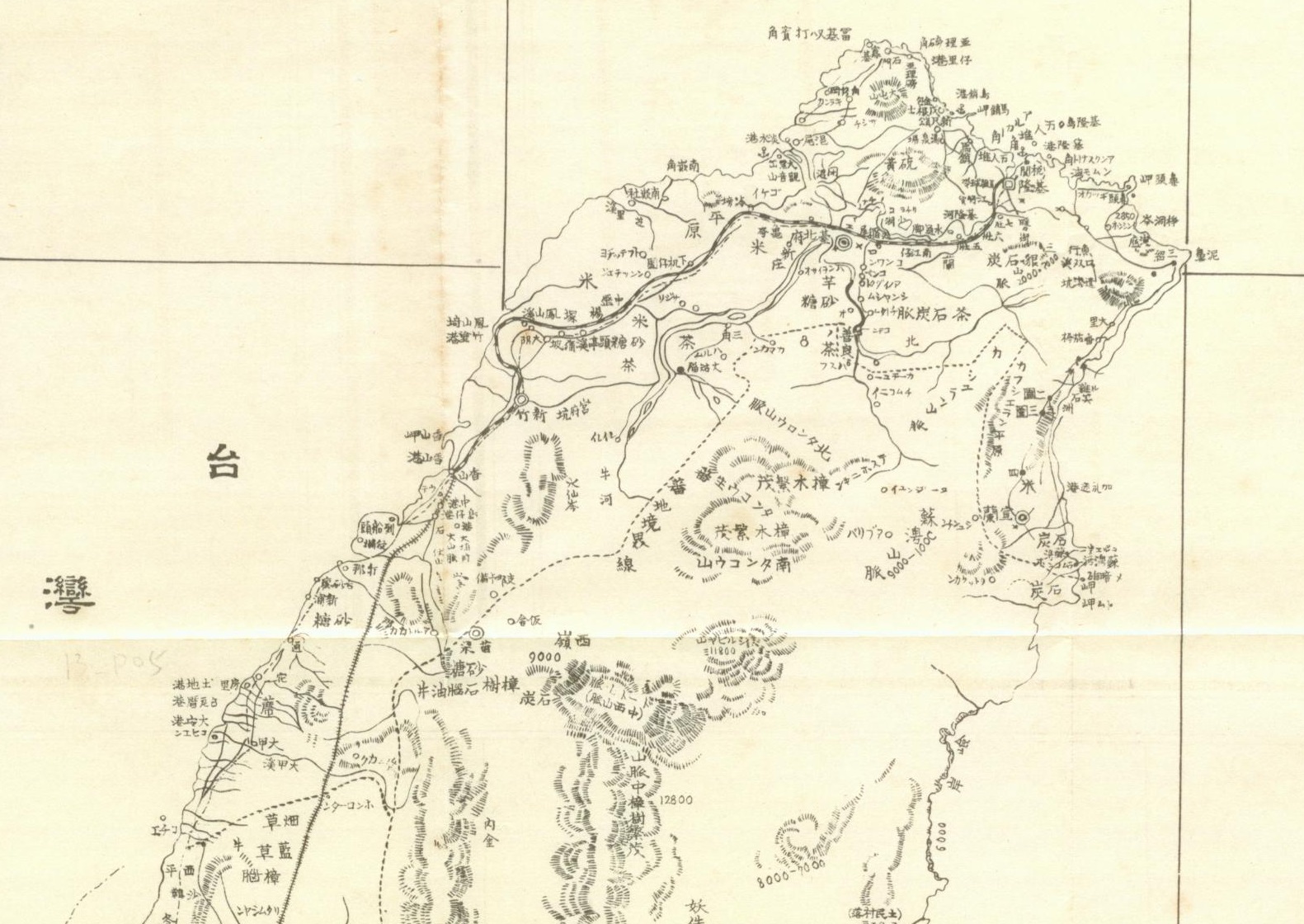
This Japanese map of Northern Taiwan was published in 1896, just one year after the annexation of Taiwan.
Previous thread on Taiwan’s old rail line maps
forumosa.com/taiwan/viewtopi … &p=1545384
Everything is so very interesting. Thank you very much for sharing all the images.
![]()
like to point out there was a location in Miaoli called 打那 on that map, which should have been 打那叭 Tanapa. It’s the name of a creek and a Pazeh village. Today the creek is more widely known as Xihu creek. There’s another river by the name of 打木溪 Tabok creek nearby.
Some interesting old maps of Taipei in English here
1 Like
There’s a few pictures in there that look exactly like the more rural areas of present day China.