Here is a summary of Igor’s and my trip to Snow Mountain in November, 2005.
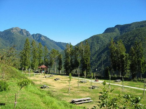
Day One: Tuesday. Igor and I left Taipei around 1pm and drove to Wuling Farm, which is actually part of Sheiba National Park: the farm is a recreation area within the park. It was originally built by retired KMT soldiers. Nice place. Looks just like a national park back home. There are 3 hotels and a campground. The campground is set on a magnificent valley, surrounded by forested mountains. It�s one of the loveliest settings for camping you�ll find anywhere.
Anyway, Igor and I stayed at the Wuling Hostel. NY1700 a night for a two bed room. It was pretty basic but the all wood design helped to get us in the spirit of the hike.
We ate dinner at the Wuling Mountain Hostel, a nicer hotel featuring wood cabins. The buffet was okay.
Day Two: Wednesday: In the morning, we drove back to this place for breakfast. It was a Chinese breakfast but at least they had toast and coffee.
Then we drove up the 7km or so to the ranger station at the start of the trail. MISTAKE. You need to check in at the police station in Wuling Farm and get your permits checked.
After sorting out our permits we returned to the station. Fortunately, they did not ask us to watch the movie introducing the park. We humped our packs onto our backs and started up the trail.
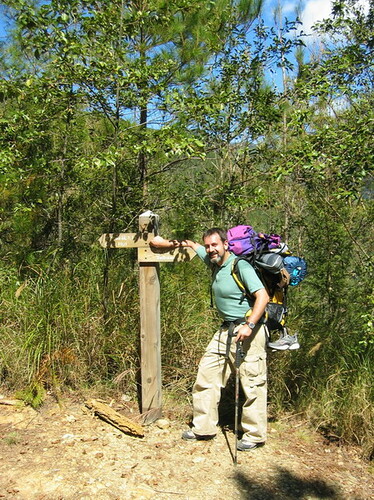
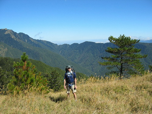
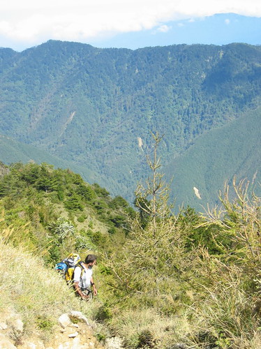
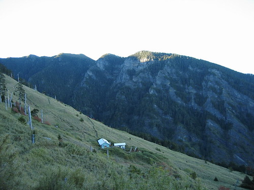
At this point we were already around 2000m. Our destination for the day, the first cabin, called Chika, was around 2300m. It is a 1.5 to two hour hike to the cabin. Not terribly difficult compared to the rest as there were some level sections; but, as it�s the first part of the trail, it likely will strike you as hard. We took 1 hour 40 minutes, including time to take pictures. In general all the times I will give are what Igor and I took to complete the sections at a good but not insane pace with plenty of stops to take pictures. Like these:
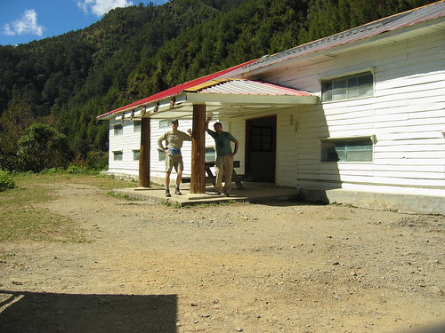
We arrived at Chika around noon. Our plan was to make a day of it at Chika and head up to the second cabin near the summit the next day. MISTAKE. There is nothing to do at Chika. It is a cabin in a clearing. That said, there were a few small trails nearby (that weren�t part of the main trail) and on one of these I was priviledge enough to see a juvenile black bear at about 30 metres away. A highlight of the trip for sure.
The cabin holds a 100 or so people. The bedding is barracks style. There is no privacy, just long bunks. If the place is crowded you have about a metre of width as your bed. There are no dividers between you and the next person.
There are flush toilets at the cabin, and solar powered lights. The kitchen is just an open room with tables. There are about 6 sinks with running water for washing. The water supply here is reliable and abundant.
After exploring a bit Igor and I realized we had nothing to do till morning. Stupidly, neither of us brought a book or musical devise, or even a deck of cards. It was a very long day, let me tell you.
Usually the cabins have a lights-out policy at 8pm. Igor and I were the only ones there, but we settled in for sleep around 8 anyway. I could not sleep till after midnight (my habit) so it was a very long night sitting there in my sleeping bag, listening to Igor snore below, and small critters scurry about outside.
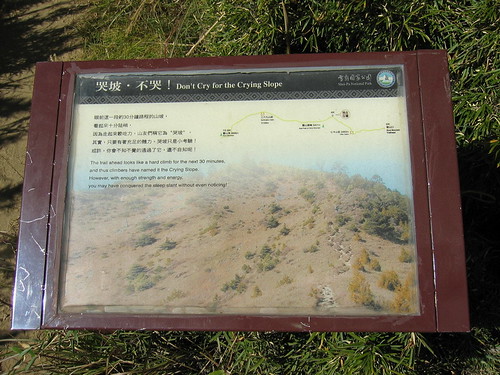
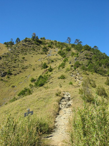
Day Three: Thursday: The next day, after breakfast, we set out. I think it was around 12pm. Our destination was 369 cabin, at 3100 metres. It was a long, arduous hike up along switchback after switchback. Very little level ground. There was one particularly brutal section of trail called the Crying Slope: it was straight up and a good challenge especially with heavy packs on.
As the altitude increases it gets harder and harder to breathe deeply. In general it is good to move slowly. Even when climbing up a rock, lift your body slowly. A few sudden movements up (such as two or three quick steps) can leave you lightheaded.
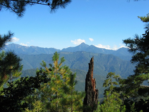
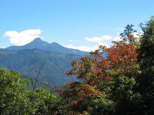
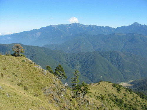
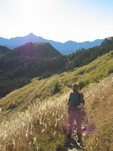
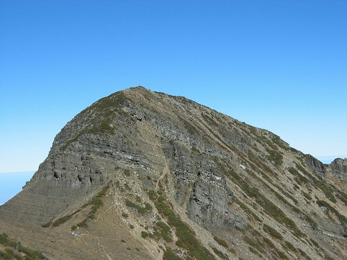
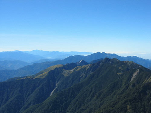
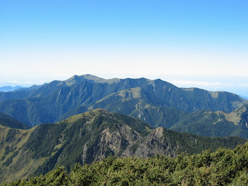
After four hours of hiking we reached the summit of the east peak. This is a bare knoll exposed to the elements and surrounded by stunning alpine scenery. We had lunch here and enjoyed the view. Actaully, we enjoyed the view all the way up. One of the best features of this hike is the ever varying terrain. You get forested mountain, and bare granite faces all folded up like a zylophone. There are open grassy fields, bamboo forest, grassy bluffs, and stands of thousand year old trees. The terrain in one direction may completely differ from what is in the other. Truly a work of natural art.
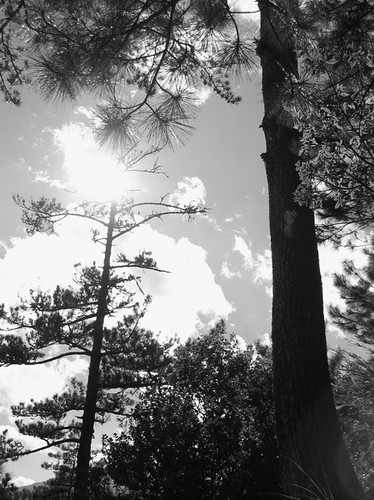
Sometimes, everything was even in b&w:
The east peak, by the way, is the last section you can receive regular cell phone transmissions. It�s amazing they even reach there.
From the east peak you can see 369 cabin off in the distance. It�s only about 2km away but it will take another 90 minutes to get there. Fortunately, they way is downhill or level for the most part. It�s a nice break after many hours going uphill with a pack.
We arrived at 369 around 5:30 I think. It was just getting dark. The cabin was similar to Chika, but that day the solar lights were down. 369 has squat toilets, not flush, which is unfortunate as it seems a lot of people won�t use squat toilets and instead shit just down the trail. This wouldn�t be so bad if they would carry their tp out. But the bastards just leave it there on top of their waste.
Anyway, we set our packs down, claimed a bed (there were around 20-30 people at this cabin - some already tucked in for the night) and then made dinner. We discovered that it would take 3.5 hours to reach the summit. Much longer than we had expected. This meant we would have to get up at 2am to be able to reach the peak at sunrise.
We decided not to do this. I knew that I could not get up at 2, hike all day (we had to return to the car the same day) and then drive safely 4 hours back to Taipei. In retrospect, it was a wise decision.
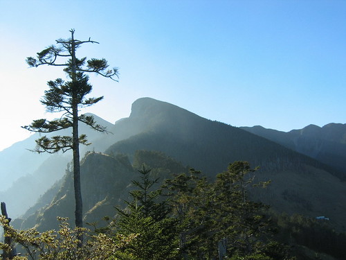
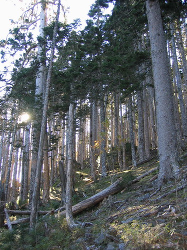
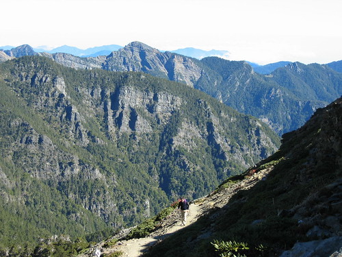
Day Four: Friday: We arose at 6am and saw a wonderful sunrise from the cabin deck. After a quick breakfast, we hit the trail. After a short while we both expressed happiness that we had not decided to do this in the dark. The landscape was not to be missed. The first section of the trail cuts through the black forest, a gorgeous old stand of Taiwan firs. Later, closer to the summit, you emerge from the shade of the firs into a section of hundreds of years old junipers. Because of the short growing season in the alpine environment, many of the jumipers were only a few feets off the ground. They were a awesome sight, with their twisted roots, and complex branching patterns.
The black forest:
When you emerge from the forest into the meadowland you are just under a kilometer from the summit. It�s still another hour or so to the top, however. But the views are inspiring. A V-shaped slope rises up in front of you and scrub covers the rocks about halfway to the summit where slides have not wiped the topsoil away. In May and June the slopes are said to be blanketed in white and pink alpine flowers. I want to see that.
In this narrow valley your perspective is off and you may think the mushroom like peak up to the right is your destination. But it is actually the softly rounded hillock that tops the slopes straight up that is the summit.
Anyway, it is a long, hard, steep climb from the edge of the forest to the peak.
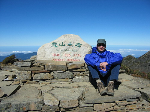
As you climb you will have to stop frequently to catch your breath, though I found I was getting use to the altitude by now (it was our third day). Igor and I were the only ones at the top when we arrived, though a Japanese group (with a 71 year old woman in the lead) arrived shortly. We took some pictures and video and shared snacks and a conversation in broken English with the others. The Japanese had come to Taiwan specifically to climb Yushan and Syueshan. They all agreed that Syeushan had the better scenery. It was hard to imagine how it could get any better. We had perfect visibility in all directions and could the run of +3000m peaks that compose the Holy Ridge. We vowed to come back and do the 5-day hike that covers them all.
We stayed at the summit for half an hour or so and then set off back to 369. It took us about 2 hours to greturn. That brought us to 1pm on the last day. We still had another 4 hours to hike back to the car. After a lunch and some much-needed rest, we started out again at 2pm. We had some gear to pick up at Chika and so stopped there around 5pm. The Japanese had returned here and had guides cooking for them. It would have been nice to stay for a while but it was already getting dark and we had another 40-50 minutes to hike to the ranger�s station and the car.
The last half and hour or so we had to walk in the dark using headlights to see. This experience confirmed that getting up to hike in the dark is the most dull thing one can do in the mountains.
Interestingly, when we arrived at the ranger�s station there was no one waiting for us and nothing for us to sign to indicate that we had completed the hike. This annoyed us as the park makes you jump through hurdles to get the permit, ensure you have a plan for your garbage (though half the fuckers up there littered),and require that you post what time you will start and finish the trail. What is the point of asking you to do this and then not checking to make sure you have left the mountains safely? As far as I know, to date no one had contacted Igor or I to make sure we are not dead, even though we failed to make it to the rangers station at the time we said we would (we were 4 hours late).
We had one last adventure. Driving back in the dark, we could not figure our how to lave the camping area. After several tries, and our frustration levels rising, we saw a working vehicle approach. We asked for help and they said they would show us the way out after they had done their errands. Twenty minutes later (and one false alarm where we thought they were leading us into an empty field to murder us) they led the way out. Can you believe it? The road we had taken in had washed out in the three days we were up there. There was a dirt side road beside it, but it was unsigned and impossible to see in the dark. Unbelievable.
The ride back to Taipei was long and because I was so tired there were times the glare from traffic made my eyes water so much I had to pull over. If possible, next time I would hike so that I finished on a Friday or Saturday, and then would spend the night in the campground.
A few notes:
The trail:
It is wide and clear the entire way up. It is signposted almost every 100 yards (1.1km, 1.2 km, etc.) with maps at the cabins and various points along the way. There are interpretation signs introducing trees, plants, animals and geographical features. They are in English and Chinese and add a lot to the experience.
It seems that recently they have placed small wicket fences over side trails and offshoots. This makes even the black forest area completely safe to cover. I can see how it would be possible before to get off on a sidetrail, but not now.
Guides:
There is no need at all for a guide.
Water:
There is a reliable source of water a Chika. People have said that 369 does not always have a steady source but it seems to now. Best to call before you go. There are a few small sources of water in the black forest. There is a sign now pointing to a water source (It reads “Water Source”). I followed the trail for a few minutes but didn’t get to the source. I’m not sure how far off the main trail you have to go. Probably not too far, but I was not into more hiking at that point.
Itinerary:
The itinerary Igor and I followed is not ideal. It would be best to drive to Wuling Farm from Taipei in the morning and then begin your hike to Chika around 2-3. This would get you to the cabin just before dark. You would then prepare and eat dinner and then play some card games or read before sleeping. This not only saves you having to take another day off work, but also means you don�t have to carry food for breakfast and lunch the first day.
The next day you can hike to 369. If you decide not to get up and hike in the dark (and I suggest you don�t) then you need to be moving by 7am. Even so you may still have to walk the final hour or so in the dark. This is not a problem. The trail is very clear and safe.
Note: earplugs are very useful. If people snore it can be very hard to get to sleep. I slept only a few hours each night because of the noises made by other people.
Hiking Times:
Ranger Station to Chika: 1.5-2 hours
Chika to 369 cabin: 5-6 hours
369 to summit: 3-4 hours
Summit back to 369: 2 hours
369 back to ranger’s station: 4 hours.
Weather:
Igor and I went in mid-November. It was mild around the first cabin. During the day I wore shorts and a long short. At night it got down to around 12 degrees.
It was cooler at 369. By 5pm it was 8 degrees. It probably got down to 4-5 at night. But it was warm in the cabin. During the day, up near the peak it was probably around 12 degrees. You need to bring warm clothing for the summit as it is exposed and the wind can really chill you. Gloves, a hat, a sweater, and a gortex jacket come in handy. You may not need them as you tramp through the black forest, but you will up top.
Conclusion:
We had a fantastic time and would both go back up anytime.