Across the street from this place?

More or less?
Across the street from this place?
More or less?
Sorry, this place…

Thanks Mucha Man and zyzzx, that’s some great info. :bravo:
I’ll make up a list and share it with my friend.
as nice as bob’s picture.
It is not direct in the center. in the direction from Taipei at the right side up to the hill.
Print the Chinese character out, ask inside Pingxi, an inhabitant should know it.
as nice as bob’s picture.
It is not direct in the center. in the direction from Taipei at the right side up to the hill.
Print the Chinese character out, ask inside Pingxi, an inhabitant should know it.
bob, head back toward Taipei on the 106. On the right a few blocks later you wil see the big red school. Across from this (on the left) is a map at thew bottom of some stairs in English and Chinese explaining the trail system. Head up the stairs here and follow the trail till you see a trail heading straight up to the left (with clear English signs to Cimu Feng, Shaozi Shan and Jhongyang Jian). Follow this and it will take you to the crags. At the crags follow the trail down to a big parking and then follow the road back down (.5km) to the 106 and Pingxi. Next time you can use this road to get to the crags quickly but it’s difficult to explain exactly where it is and easy to confuse with others (I still confuse it with others).
Note that when you are on the crags you can see all the way down the Jilong Valley (and of course look down on Pingxi to get your bearings).
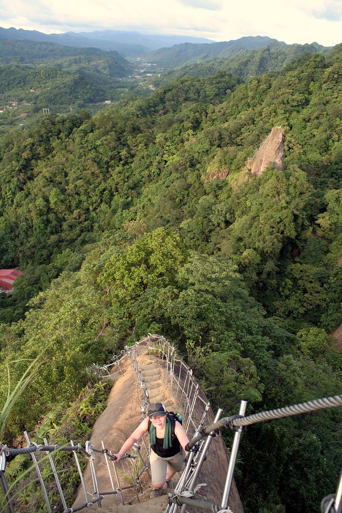
Here’s my blog on the hiking:
hikingintaiwan.blogspot.com/2008 … rails.html
Shaozi Shan has an old climbing trail for a few meters but you might need climbing equipment or at least climbing shoes. i didn’t dare it with boots. Has someone tried it?
I have been there 3 or 4 times, everytime i got lost for a few minutes. Look for the trail info and ask, you will find it. Nice pictures made by Mucha Man.
Absolutley cool guys. Thanks. I’ve been dying to find that place.
(Brilliant idea stretching it like that MM).
[quote=“Mucha Man”]bob, head back toward Taipei on the 106. On the right a few blocks later you wil see the big red school. Across from this (on the left) is a map at thew bottom of some stairs in English and Chinese explaining the trail system. Head up the stairs here and follow the trail till you see a trail heading straight up to the left (with clear English signs to Cimu Feng, Shaozi Shan and Jhongyang Jian). Follow this and it will take you to the crags. At the crags follow the trail down to a big parking and then follow the road back down (.5km) to the 106 and Pingxi. Next time you can use this road to get to the crags quickly but it’s difficult to explain exactly where it is and easy to confuse with others (I still confuse it with others).
Note that when you are on the crags you can see all the way down the Jilong Valley (and of course look down on Pingxi to get your bearings).
Here’s my blog on the hiking:
hikingintaiwan.blogspot.com/2008 … rails.html[/quote]
Quite awesome photo and blog! thanks for the submission!
Is that crazy Pingxi hike too steep and dangerous for a 6 year-old? My wife says it is.
Actually, she wants to go hiking at Pinglin tomorrow, not Pingxi. Does anyone know of any good hikes at Pinglin? I searched for it and found this thread. The only reference I found to hiking there is this, by Mucha Man:
Is that a worthwhile hike?
thanks.
EDIT: Ok, a google search was more fruitful. Here are a couple of articles on Pinglin hikes by Richard Saunders. Sounds nice. We’ll be sure to bring our swimsuits, too. ![]()
chinapost.com.tw/print/211285.htm
chinapost.com.tw/print/208620.htm
The Pingxi crags are a bit much for 6 year olds though you do see people with little kids up there. However, you don’t need to climb the crags, there are lots of great trails in the broadleaf fig forests. From the village centre head up tothe red brick elementary school and look for the stairs (and map board) on the left which should be just before the bridge.
You can do a few hours with some gentle hills and get to the back meadows which have terraced fields and water buffalo. It’s a really beautiful little spot. Just don’t head up to the crags or to Fengtou Point, which is a scary ridge walk for adults. But don’t worry you aren’t going to stumble upon either path by accident.
Pinglin has some minor stair walks around the village, and some nicer hikes that are harder to find unfortunately. The bike path would be a bit dull to walk though there are a few short sections of nice trail down by the river. At the end of the bike path are some steep but wide trails that head over the hills toward the coast. But honestly, I wouldn’t go to Pinglin unless you are with someone who knows the area.
Go to Pingxi and take the back trails. Tell your wife these are well marked and mapped whereas the Pinglin ones are not.
Yea, I just figured that out from reading Richard’s articles. He describes two nice hikes, but both of them start after a 45 minute drive in the hills from Pinglin, which he figures makes the trailhead 2 hours from Taipei and it does sound like one could get lost if not very careful.
Pingxi does sound better for now. I’ll see if I can convince my wife – she does like hiking and she said that’s the plan, but perhaps she has a secret agenda of sitting in Pinglin teahouses or strolling a tourist street. ![]()
Well she can hang out in Jingtong just down the street at a tea house restaurant in old Japanese era house if she wants. Actually you would like it there too so drop by after the hike. Good food and lovely old atmosphere.
It’s 1km from Pingxi. Just head to Jingtong and when the road makes a sharp right (and crosses a bridge) stay strait and park on the side of the road. Below to the right will be a lovely old Japanese villa with gardens. This is not the restaurant. Instead pass this and look for a row of smaller japanese houses. The restaurant is obvious.
Thanks a lot. I’ve printed out your comments and will do my best to convince her. Sounds great. 
Oops, sorry. I just checked googlemaps and they say it’s a 2 hour drive to Pingxi because one has to take highway 5 all the way out to 2, up the coast and then through Toucheng. Do you agree? One can’t simply cut left off off 5 before hitting the coast and somehow make your way more directly to Pingxi?
That’s the longest route possible I would imagine. Take the tunnel near Taipei 101 to Muzha and head east toward Shenkeng and Shiding on the overpass. At Shiding head east on the 106 to Pingxi. From Taipei 101 it should be 30 minutes to Pingxi so maybe an hour from where you are.
I’m not sure exactly where you are but take the fastest route to Shenkeng. It’s 20 minutes from there. And from this direction the red brick elementary school is just before the village.
So did you go? I realized later that the fastest route for you would be to head east on the 5 and then cut down over the mountains on the 33 or 31 I think it is, which connects the 5 with Pingxi.
Yes, we went to Pingxi that weekend but it was raining then, same as now, so we only did a short hike but enjoyed it.
As for tomorrow, has anyone hiked from FengKweiKuo to QiXingShan?
How long does it take?
It’s mostly rolling hills, right (since it goes along a ridgeline rather than ascending a peak)?
Can one catch a bus down the hill from the QiXingShan parking lot? I’ll want to get back to Songshan Dist. What do you think would be the best bus/transport options?
I’m aware I’ll likely be rained on for most of the hike, but as long as it’s not a torrential downpour that’s fine.
The regular daily afternoon downpours have made hiking less appealing these days…
Gosh living here in the bay area has really made me realize how much it rains in north taiwan??? And with global climate change they are forecasting up to 500pct more rain???
Good grief. It may end up just being rain 24/7 365??? Gads.
So hows you doing Chris? Miss Berkeley yet?