I want to start a sister-thread to the “How was your ride today” about hiking. (not sure if this is the right forum, or maybe it belongs into the “health” subforum)
And start with my hike from yesterday:
place: yangmingshan (beitou side) route: qingtiangong 清天宮 → datun west peak 大屯西 → datun south peak 大屯南 → erziping 兒子平 → back
distance: 8,5km
elevation gain: 650m
duration: about 3 hours without breaks
weather: clear sky, 26 degrees
great loop I already did many times in different variations.
rope / climbing sections on the two datun peaks are a lot of fun.
you can get easily to qingtiangong trail entrance by bus, but I rode my scooter there.
tip: about 200m up from the trail entrance are some local farmers which always sell produce without using pesticide. great veggies and the delicious oranges are in season!
bought a big bag of 20+ oranges for a little over 100nt.
I did a similar hike just the other day. It wasn’t as long nor as fun as @taiwantiger’s. I went up to Datun’s main peak which is higher than west peak by about 100 m. But it’s certainly not as fun as doing the rope climb on west peak’s dirt trail. Datun main is the second highest point in Taipei and the highest point reachable by road (Was thinking about biking up but felt I was too out of shape from being out of the saddle for so long due to the recent bad weather). I was hoping to catch the sea of clouds that people were posting on facebook that day. But by the time I got to the top, the clouds had risen higher, and I ended up in the clouds. All I saw was this.
Distance: 5.2 km
Elevation gain: 277 m (starting from Erziping)
Duration: 1.5 hours
Weather: foggy with glimpses of blue sky
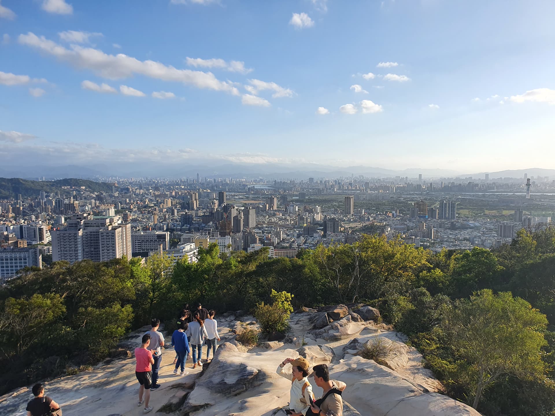
name: battleship rock / junjianyan / 軍艦岩
area: beitou (shipai/qilian mrt)
route: 國立陽明大學National Yang-Ming University
→ battleship rock 軍艦岩 → down the other side → back
distance: 5km
elevation gain: 270m
duration: 1:10 hrs (fast pace)
description:
starting with some boring road walk / lots of stairs you get rewarded with a great view from battleship rock. continuing on the other side with dirt trails, climbing over big rocks, more pretty views and some rope sections you will end up in a beautiful jungle where taipei seems quite far away.
alternative routes:
there are lots of different variants (eg. starting from qilian mrt station to skip the road and hike up along the ridge, or another where you end at the xinbeitou mrt)
notice:
the first section from university to battleship rock can get quite crowded on sunny weekends.
this is my twice a week running trail, you can incorporate the alternative routes to keep it interesting
this trail also is ok for hiking after heavy rain (or with light rain) and doesn’t get too slippery, although I then skip the rope sections.
All I do is hike. Too much of a chore to post.
I follow a couple of people on All Trails to see what trails they discover, or what trails are actually no longer passable after years of disuse.
Its a good app to discover people and places. And I particularly rely on downloading offline maps.
I can’t tell if you are using Strava or All Trails.
Nice hike! I’ve done it from Qilian along the small and sometimes overgrown path on the ridge, through the woods and the YMU athletic field many times.
No pictures of great scenery because there isn’t much to see on this hike. This is my weekly hike I do with my dog. It’s a little less than 3k up, which I do partly running and partly walking, and then I walk down. A couple hundred meters of this is through the woods, but it’s mostly a road that I go up and down on. Almost no cars or scooters and lots of shade, making a late start on Saturday morning possible even in the summer.
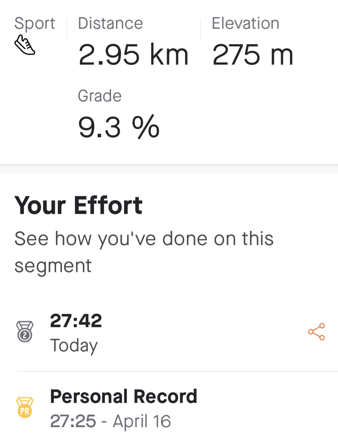
So I finally got a new pr on the segment I run/walk about once a week. Also a pr on a shorter part of that. After all my illnesses this year (nothing serious) this makes me feel really good, like I’m finally getting completely healthy again. The pictures are from two weeks ago when the morning weather was better.
So my pr breaking on this hike started at the end of last year. For the longest time, I thought my pr of 27:30 could not be broken because that was set due to a gps error (I’m sure that day my gps thought I was at the end when I really wasn’t). I finally did pass the mark, but things didn’t stop there. I kept setting a new pr about once a month. Today I got yet another pr. I really should be posting this in a running thread because my previous run/walk method of doing things on this course has switched to all running. Anyway, I’m extremely happy with today’s results.
I went up the mountain next to my apartment this morning before work. After about 1k, I saw our plumber. Very skinny guy and very humble the way he acts. He also wears this really goofy hat that has a wheel in the front that spins in the wind.
Anyway, after he saw me, he started running. It was slow because it was a mountain road. To make a long story short, I never caught him the 2k or so after he started running to the top of the mountain. It turns out it was my third fastest time on that segment (off by 40 seconds from my pr for the segment).
We walked down together and he told me he was entering a marathon next month.
What is the moral of the story? You never know by looking at a person how well they can run. At the bottom of the mountain, I thanked him for making me push myself harder than I would have without him there and we parted ways.
So far in Taiwan, I’ve had a barber who could run really well (trophies all over her little shop), and now a plumber.