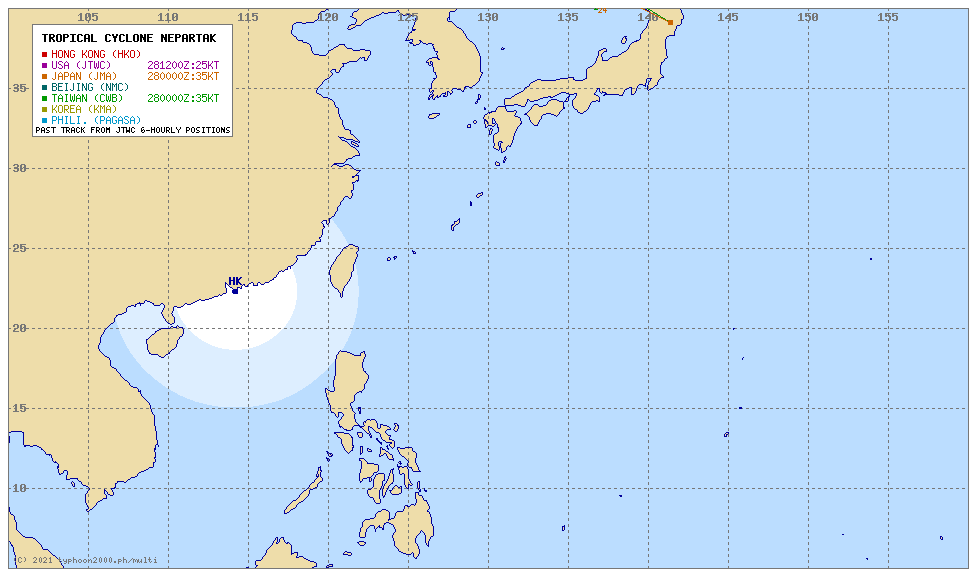
Both Japan and Hong Kong have the path going straight across Taiwan before moving north.


It changes almost every hour, now on Windity landfall appears to be on top of my home, haha. (…)
The turning point is always the one that’s harder to predict, too many factors involved. It could be anywhere between:“No holiday / maybe half a day off in Keelong” to:“One or two full days of holiday in Yilan, Taipei, Keelong”.
[quote=“Ibis2k12”]It changes almost every hour, now on Windity landfall appears to be on top of my home, haha. (…)
The turning point is always the one that’s harder to predict, too many factors involved. It could be anywhere between:“No holiday / maybe half a day off in Keelong (Jilong)” to:“One or two full days of holiday in Yilan, Taipei, Keelong (Jilong)”.[/quote]
Is it monster sized? How fast is it moving? (faster is better in terms of less damage) If it is big and lingers, we’re doomed.
Forecast is that it will top at a category 3, downgrading as it starts to turn to the North once it approachs Taiwan. Nothing even close to Soudelor/Dujuan from last year.
It’s coming our way fairly quickly, but it will definitely slow down once it starts turning. Without a correct trajectory there’s still now way to know how long it will have fun around here, but so far it looks like once it starts heading North it should all be over fairly quickly, and people in Shanghai will be able to enjoy part of it.
Anything could still happen though, last year we had a typhoon off the coast of Kaohsiung that spent there much longer than expected, dancing around and dropping a lot of rain.
Keep in mind that if Windity is right:
We’re going to be &#%^$&$( in the *@&^($% like a #&^$ during a (#^##(#&#(.
Some (not very good) updates.
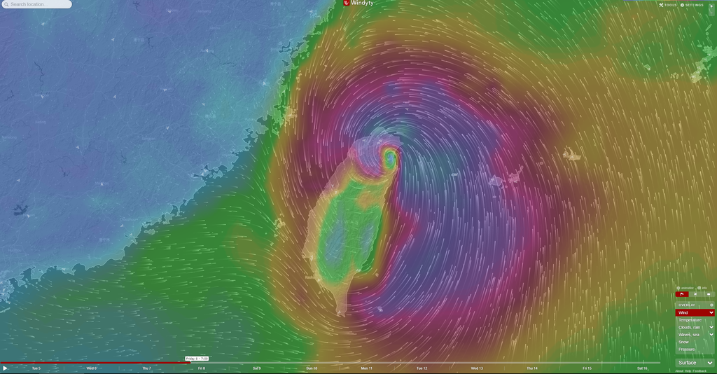
Most models have Nepartak dodge Taiwan, but it may also hit us directly. Windity has it make landfall between Hualien and Taidong.
I’m scheduled to fly into Taipei from Korea on Friday July 8 at night, plane is scheduled to land around 10pm. At that point, it will be between Korea and Taiwan, according to the latest forecasts. Will it be likely that they will still fly over the typhoon, because 30,000 feet should be well above it. Mostly just wondering what the likeness of having my flight seriously delayed or canceled is.
The planes try to fly far away from them, but there may still be some turbulence. Wifey is flying past Taiwan tomo . Hope she’s far from the storm.


Taitung? The tree!!! Nooo! It is healed now!


Windity shows landfall in Hualien.
Most models I’ve checked today show Nepartak making landfall somewhere around the center of Taiwan, one of them had it go even further south, crossing the mountains and passing over Kaohsiung, others still show landfall in Yilan.
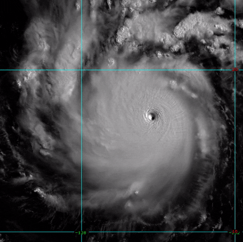
In 24 hours it went from a :“Meh” typhoon to a super typhoon, close to be marked a category 5.
Edit: nevermind, just confirmed category 5 by the joint typhoon warning center.

Another model that show it going further South.
The wife and I are due back from Okinawa on Friday morning around 1030. My son is flying in from Hong Kong around 1330. So we are watching developments very carefully. The Typhoon does seem to be getting pushed further south, whether that’s good news for me I don’t know.
Right now, it has wind gusts above 270 km/h, may strengthen further.
That’s an interesting first typhoon of the season, holy crapload of doom.
Well…there goes my weekend plans. Time to binge watch TV shows on Netflix.
Does anyone know where can I rent a computer/laptop? I’ll be working from home. 

Every model is struggling to define a clear trajectory, it could really land anywhere from Taidong to northern Yilan, not like Soudelor/Dujuan where we had a very good estimate of landfall a few days in advance.
No idea about the possible holiday status, but I guess all the East Coast will stay home on Friday. For other areas it will depend on the landfall location.

The column on the left represents Hectopascal, a unit to measure pressure. Nepartak went from:“Meh” to the same low pressure of Soudelor/Dujuan in less than 2 days.
Yesterday, CWB informed that:
[quote]Having grown in intensity from a tropical storm into a typhoon overnight, Nepartak continues to pick up strength because it has a small vertical wind shear – the change in wind direction with height in the atmosphere – and is passing over a warm body of water, the bureau said.
[/quote]
Meaning it is getting stronger… ![]()
The government is ramping up prep:
[quote]The government is planning to monitor the geology of 34 risk-prone areas around Taiwan and set up pre-warning systems to protect residents in those areas and their property, the Council of Agriculture (COA) said Tuesday.
Lin Chang-lin (林長立), deputy director of the COA’s Soil and Water Conservation Bureau, said rainstorms in Taiwan have been more intense and lasted longer in recent years and could cause a “major catastrophe” similar to one that occurred in 2009.
[/quote]
Other interesting news:
[quote]The transportation minister said Tuesday he is fully confident Taiwan Taoyuan International Airport will be flood-proof if an approaching typhoon batters the country with strong winds and torrential rain in the next few days.
[/quote]
Meaning:

CWB issued the warning. Still no holiday.