So you wanna hike the Fu-Ba National Trail? Well, there is not a lot of info out there on how to do this practically. Just about a paragraph or two in the main guide books about Taiwan. I just got back from hiking this trail and this is how I recommend doing it if you don’t have your own transport and do not make any reservations in advance. There will be some things that are missing from this and if anyone wants to add additional info, please do so. There are a few questions I still have myself.
I hiked the trail going from Lalashan forest park (actually started in Shang Baling) to Fushan. This includes my perspective on how to do it the other way around, from Fushan to Lalashan too.
I took the bus from Daxi and despite what it says on the board at the bus station, the bus does not leave at 9:50am, but it leaves at 11:30am. It takes about an hour and a half to two hours to get to Shang Baling (Upper Baling.) For accomodation, there are a bunch of B&B places around, and the one mentioned in the guide book “Magic World Country House” is quite a ways down the road from the main town area of Shang Baling. Doesn’t make much sense to stay there unless you have your own transport or want you to walk even longer to get to the forest park.
Fortunately, there is a reasonably priced hotel that is more than decent in the building that is adjacent to the fire station in the “town” area of Shang Baling. The bus pretty much drops you off right there. It cost me $1200 for the night and it was a Saturday. It only has a sign in Chinese. This is still a little ways from the forest area. To get to the forest area, it is a hike to the entrance, about 5-6 kilometers, uphill, and then from the entrance, it’s about another three kilometers to get to the exhibition center inside the park where the trails start for viewing the trees, the stuff you actually want to see.
To get to the forest area from Shang Baling, you can walk, but it takes a while. I did see a couple taxis going around though. Also, in the morning, I was making my way up there a little after 9am and a bus came around the corner and I waved it down and hopped on. It was only 25 NT and it dumps you off at the entrance for the forest park, so it was still another 3km to the part of the park that you want to see. I have no idea what the schedule is for that bus, or if it was the same bus that comes from Daxi. There wasn’t a number on the bus and it was all in Chinese. Does anyone have any info on this bus or know its schedule? After I got off, the driver just stayed near the entrance and probably waited for people to come back down and left at a certain time.
There are a bunch of other places to stay further up the road on the way to the forest park. I don’t know if any of those are regular hotels, they look mostly like B&Bs and probably cost a lot. Does anyone know any other regular hotels in the area?
So to get to the forest park area from Shang Baling, the options are: one of a couple taxis around (but they seem quite spotty), the random bus, walking or trying to hitch a ride. I even had some nice Taiwanese people offer me rides up to the park while I was hiking up.
Before you go on the trail, you should go to the police station and get a mountain permit (ru shan.) It’s free and you don’t really need anything special, just fill out a form. The police station is right next to the fire station, so it’s right next to the hotel I previously mentioned. The police officer there is actually quite friendly. I wasn’t even asked to see my ARC or passport, but there is a section on the form that asks for your ID number, ie passport or ARC.
In order to get to the trail, you have to go through a section of the forest park that is closed off. There are little maps all over the place in the forest park area with all the ancient trees. You can see a little yellow dashed line going out of the forest area on the map and that is the Fu-Ba trail. If you follow the map, you can find it easily. But again, the area where the trail head is is currently closed. I don’t know why, I walked around in the area and there was nothing wrong, and it didn’t even look like they were doing work. I just went through there anyway; nobody even tried to stop me. It’s really a shame, because the parts they have blocked off area the best areas of the park. I just don’t know why they are doing this right now.
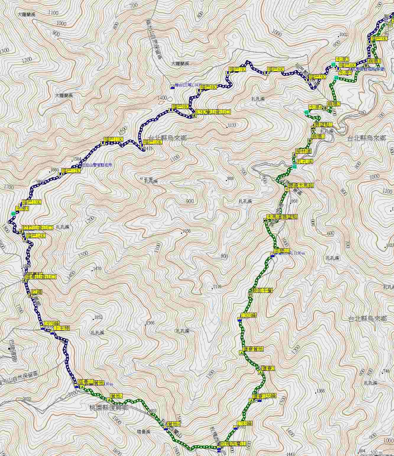
Once you’re on the trail it’s another 17km until you reach the other side in Fushan. The trail is very easy to follow. It can take up to six hours. I did it in five in rainy weather. That should have slowed me down, but it was rainy and cold and I was hauling ass to get it done quickly and took minimal breaks. There are many more huge ancient trees and other beautiful sights along the way. Unfortunately, there aren’t any signs here like in the forest park to tell you how old and tall they are. If you want to hike up to Lalashan, there is a part where you can do it. It is a steep climb, with ropes to pull yourself up on. When I went, it was raining and very slick, I wasn’t even going to attempt it. It looks quite precarious as it is, and in the rain, it’s almost certainly a death trap. There are also signs pointing to other trails along the way which I don’t know anything about. Does anyone have any info on those trails?
Along the trail at the half way point, 8.5 kilometers in, there is a good campsite. There are other places to camp, and it’s obvious where others have made camp from the charred wood and trash strewn about on the trail. Is it legal to have a campfire on the trail? And obviously, you just need to bring back out whatever you brought in. It makes me sick to see trash strewn about in a place that is supposed to be pristine.
At the end of the trail, there is the suspension bridge and you’re in Fushan. There is almost nothing in Fushan. One cafe, one restaurant, and that’s about it. No taxis, no hotels, no shops. It’s 17km to get to Wulai. I was only able to make it to Wulai since some nice Taiwanese people gave me a ride. I walked up to them casually asking to point me in the direction of Wulai. They said it was 17km away and that there were no taxis. I got lucky with this one, or it would have been another 17km to walk that day. You could probably find somewhere to pitch a tent if you wanted to camp and then head up the road the next day. Or if your Chinese is good and you know a taxi company in Wulai and are willing to pay the likely exorbitant fare, you might be able to get a cab. Either that, or bring along your Marty McFly hoverboard.
At about the 5-6km marker on the road to Wuali there is the police station. Make sure to check in here so the police know that you’ve made it out alive.
Now, for doing it the other way around, this is how I imagine doing it based on my experience.
First off, from what I read and experienced on the trail, it will take longer to go from Fushan to the Lalashan forest area. It is slightly up hill, although some portions in the beginning will be steeper and more treacherous to cross. It can take 8-10 hours to hike the 17km from Fushan to Lalashan from what I have read, and this does seem accurate.
To get to Fushan, the only real way to do it would be having your own transport, or getting a taxi from Wulai. You would have to wake up pretty damn early to be able to get there to allow yourself enough time. I would recommend staying at a hotel in Wulai and waking up early to do this. I haven’t found much info about regular hotels in Wulai. They all just seem to be the hot spring hotels which cost a lot. Anyone have info about regular hotels or other places to stay in Wulai? Is it possible to camp? I guess you could also go to Wulai the night before, get a taxi to Fushan, camp there for the night, wake up and hike.
Before you get on the trail, make sure to get your mountain permit (ru shan) from the police station which is at about the 5-6km marker coming from Wulai.
Then you cross the suspension bridge and you’re on the trail. It’s 17km until you reach Lalashan forest park. You are still a ways off from Shang Baling once you are at the end of the trail. However, it seems like you could camp out on the two large wooden decks that are right next to the trail head. You’re probably not supposed to do this, but it could be done in a pinch. Once the trail “ends” you still have to walk through the park. It’s a nice walk and not too long. Then you will reach the parking lot area near the exhibition center. You can try hitching a ride here, as it would be another 3km to the park entrance, and then even further back to town. You could walk the 3km to the park entrance and take the gamble that the aforementioned bus will be there or the off chance a taxi driver has nothing else to do and is waiting around for a fare. However, it wouldn’t be that bad to walk to town from here because it’s all downhill. If you are still hiking at dusk, just take proper precautions, reflective clothing, flashlight/lantern and you should be fine. It’s not that dangerous to walk down back to town at night on the road. There isn’t a lot of traffic, no hairpin curves that you can’t see around and there is enough space for you to walk on the side of the road safely and comfortably.
As for getting back to Taipei from Shang Baling, I have heard that there are buses that can take you to Taoyuan, and other places. I have no idea what the schedules are or where you would catch the bus. Does anyone have info on this? Which places can you go to that you can easily to back to Taipei from? Daxi would be another option, you can get back to Taipei from there, the 9103 takes you to Yongning, the end of the line on the MRT blue line.
It’s a very rewarding trip and can be done in one weekend if you manage your time efficiently and have the right information. Please if you have more info, fill in some of the gaps or add whatever you can. Also, if you have any questions, or comments, feel free to post. Happy hiking.

