We didn’t do the hike mentioned below. Instead see further into the thread for our river tracing trip out near Sandiaoling. Complete with pics. [/color]
Okay, a new and long hike, weather permitting, which it should. Chance of rain only 30% and for the afternoon.
The hike is a long one, from Shiding (where we started the Huang Di Dian hike) back to Muzha. The entire hike runs along a ridge affording great views over mountain ranges and the city. There shoud be lots of scrambling, hugging cliff edges, a few clamours up rock faces, and all sorts of fun, mildly challenging stuff.
Haven’t done much of this trail so I can’t say exactly what it is but it’s well signed, and natural. If it looks like rain we won’t do it.
The main section of the trail is marked at 4 hours by Taiwanese signs. Then it’s 30 minutes or so downhill to where we can catch a bus or start another simple 40 minute walk up to Zhinan Temple where a lovely free teahouse awaits us.
Near the end there is a small stream to wash off in though nothing you could swim in.
This is a long hike and the weather will be warm so 2 litres of water and a lunch.
We meet at 9:30 at Muzha MRT station. We catch the infamous 666 bus to Shiding. Should arrive at 10:15 in Shiding. Expect to finish the hike around 4-5pm.
Damn, blast and bugger! Just when I’d cleared my desk and thought I could look forward to a free weekend, yesterday afternoon I received a request to translate a large, very important and highly urgent piece of work. I need to get it done by Monday, if possible, which means I’ll have to work flat out all through the weekend. As it’s the plan for implementing a major new government policy that’s made a lot of headlines this year, and as they’ve offered an exceptionally high rate for doing it, there’s no way I can say no.
Wow. I almost fell off that ridge, but I tried to tackle that hike with running shoes. Bad idea. Despite almost dying, I thought it was a great hike and not often you get the chance to take the 666 to Shiding, is it? IIRC there’s lots of ropes (use them) as you make your way up, and some crazy farmer who will want you to drink (buy) some tea. You’ll be climbing above the new #5 highway and its tunnels–hopefully construction/traffic noise will be minimal. Be careful along the ridge. Do take along plenty of water. As mentioned, the end spits you out in and amongst the hills of Maokong. We flagged down one of the small Shin-shin buses down to the Zoo MRT. Man, I was one wasted, soiled hiker that afternoon. That said, it’s a good hike. Enjoy the view!
Sorry MM. I’m in the middle of my busy work season. Give me another month and it’ll all be over and I’ll really enjoy the hikes again. They have made Taiwan easier to live with/ on/ in.
Okay, I am cancelling this hike and going on a picnic with my wife tomorrow. If the weather looks good I will do the hike on Sunday. I will do some long hike on Sunday. PM me if interested.
sorry for the late input. Just had a busy day. And this weekend is not looking any better. Also, the knee is not doing that good. I hope we can join in as soon as possible.
BTW, P and I and seeker4 and your wife tried to river trace today up to the waterfall at Sandiaoling. Pretty fun but we were stopped by a small waterfall about 100 metres from the big one. No way to get up without ropes and stuff. Will try again in the summer.
But the effort to get there is going to argue against this ever replacing the Wulai swimming hole.
A minor one. Along the way, not really. All total, there were maybe two-three places deep enough to get wet, but not wide/long enough to actually swim. The stretch between that small, but as yet unsurmounted waterfall (not shown here) and the base of the large fall is unexplored, so don’t know.
This photo shows the first pool of any size (foreground) where an intrepid hiker is crossing the underwater bridge between two deeper areas:
This one shows some guy, post-somersault, indicating where he should be standing on dry ground:
And then same guy’s twin brother showing the depth of the smaller second pool:
The waterfall that stopped us is just beyond the area in these photos, behind that large green rock. There’s another small pool under that fall that is quite a bit deeper.
River tracing is a really fun way to enjoy the type of terrain that is so abundant in Taiwan.
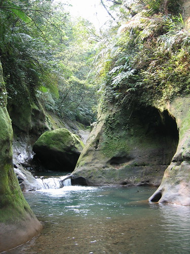
A few more photos. It’s a pretty interesting little canyon. The rock is soft, as in so many areas of Taiwan, and fascinating features result. See the cave. My favorite sight was the little stream running down the rocks that actually cut a channel in the slope.
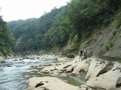
Here’s the Keelung River. We had to hike up it to the start of the other stream. We figured the best way in summer would be to bring air matresses and float down. It’s only .5 km and the stream is wide at this point.