It is a Category 5 already. And gathering speed. My money is on Friday off. Or swimming to work.
Unless it gathers even more speed, it will dump a whol lot of trouble on us. And the gusts of wind at lunchtime tell me that is a likely scenario. Friggin wind almost took my plates away!
So I’ve been working in TW for quite some time and this year I am working at a new company. This doesnt affect me much but I am curious if anyone else has ran into this. I received a message from HR saying government policy is half-pay for Typhoon day. Anyone else hear of this?
Looks like we will be in a lot of trouble. 17 degree wind which is basically car toppling, tree breaking, window smashing, don’t go out kind of weather.
Hence buy what you need today. Beer and ice. Snacks. Pet food.
BTW mayor Ko came out saying this time there would be no yellow water in Taipei. Hence, water gallons all sold out.
Furthermore, we really need to keep an ear to the ground and a escape route planned, as depending on the rain and wind, if they surpass the established limjts, we might be sent home earlier.
MIN SURFACE PRESSURE 905 HPA
MAX SUSTAINED WINDS NEAR CENTER 58 METER PER SECOND GUST 73 METER PER SECOND
That’s a monster, and it grew in size during the last 6 hours.
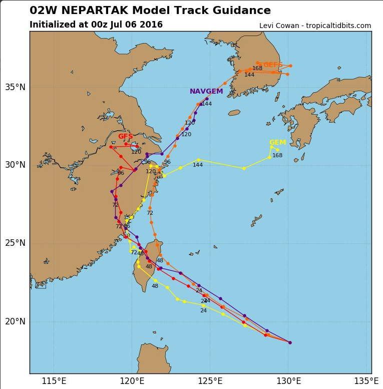
This was posted around 10.30pm, it’s the same followed by Nepartak, CWB, JMA, Windyty and others. They predict landfall north of Taidong, with the coast between Taidong and Hualien getting the worst of it. Let’s hope it slows down a bit during the night.
Based on what I’ve experienced, it’s far better for these things to move through as quickly as possible. If typhoons linger, all kinds of unpleasant things can happen.
Btw, I learned this evening that my Cathay Pacific flight from HKG tomorrow has been cancelled. I recall that others may have flights scheduled too. Check your with airlines. I expect lots of cancellations.
Nepartak is supposed to be at its peak now and shuld lose some intensity by the morning. Some forecasts claim Cat.4 on landfall, rather than 5. Better than nothing, I guess?
We should be aware of the tendencies of typhoons hitting the center of Taiwan, to veer north, rather than quickly pass straight across the island as these models suggest. Those mountains, combined with the spin is like the wheels of a car aquaplaning, then coming into contact with a dry surface.
Based on what I’ve experienced, it’s far better for these things to move through as quickly as possible. If typhoons linger, all kinds of unpleasant things can happen.
Btw, I learned this evening that my Cathay Pacific flight from HKG tomorrow has been cancelled. I recall that others may have flights scheduled too. Check your with airlines. I expect lots of cancellations.
Take care, everyone!
Guy[/quote]
Where do you find that info? I’ll be flying China Airlines from Incheon to Taoyuan on Friday night. I am coming from the US and my flight from the US to Korea shouldn’t be effected, but I am sure that a flight going from Korea to Taiwan on Friday night will be effected either directly by the weather or by the other cancellations and delays that resulted in the last day and a half or so. I checked the China Airlines website, but perhaps since it is still two days away that they haven’t made a decision about it.
I have not flown CI, but I’d advise you to keep checking their website for announcements/travel advisories. Also, do make sure they have your contact info in their system. With a Friday evening flight, I imagine you would be good to go, but with these typhoons, youneverknow.
We’re working at the Ocean Home festival here in Hualien. This is the biggest typhoon to hit the E coast that I’ve seen in 10 years. Current landfall is forecast for south Hualien County (maybe Chenggong). We’re north of there, and are going to get hit very hard.