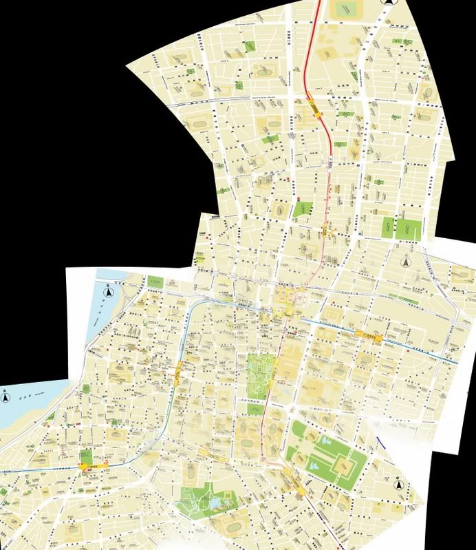
I’ve been trying to find a high-resolution JPEG (or PNG/GIF/PDF) map of Taipei (it’s more convenient for me to have it on my laptop than carry a paper map). I’ve tried using Google Image searches but it’s been somewhat fruitless. phys.ntu.edu.tw/new_english/ … peimap.jpg is ok but it doesn’t quite extend out far enough in each direction. Other maps that do cover the whole of Taipei are not detailed enough.
My Chinese isn’t that great so having English as well as Chinese characters for streetnames and landmarks is a must.
Any suggestions?
I like the maps on the MRT site, but they’re patchy. Would love to have a seamless map of that type covering the entire city.
None of these are great, but they’re the best I’ve found.
phys.ntu.edu.tw/string/Taipei-map.html
traintesting.com/images/Taipei_map.jpg
mapshop.com/Travel_Maps/Far_ … loseup.jpg
gis.nat.gov.tw/village/search_road.jsp
This last one requires you to input road names etc. in Chinese to get a detailed map; if you selected 民權隧道 the Minquan tunnel, you’d get this image:

It’s pretty good but cumbersome even if you know Chinese.
You might have to buy a quality paper map and scan it.
Here’s one (albeit from 1898!!). You can see a piece of it in my avatar!
http://academic.reed.edu/formosa/gallery/Map_pages/Place/Bancroft_S/BForm2B_S.html
[quote=“Chris”]Here’s one (albeit from 1898!!). You can see a piece of it in my avatar!
http://academic.reed.edu/formosa/gallery/Map_pages/Place/Bancroft_S/BForm2B_S.html[/quote]
That helps. 
BTW: Google Maps now covers Taipei, too, though of course it’s only online.
Thanks all! I think I’ll take Jaboney’s suggestion and see if I can download all the maps off the MRT site (e.g. home.trtc.com.tw/INFO92/ebig.asp?SID=050) and stitch them together (hopefully I can automate the process a bit!) as they are pretty nice looking and cover all my requirements. If I do get around to it then I’d be happy to send it to anyone else who PMs me.
Cheers!
stevegan, I tried that, and it didn’t work. There are gaps, and some of the maps are differently oriented. It was a real pain in the ass. Hmm… come to think of it, I now have a far better photo stitch program. Maybe I’ll try again and see what the best I can come up with is.
The MRT maps are pretty good but I think you might have some trouble stitching together areas that do not have MRT that close to each other as it does not connect.
You can go to the Taipei Main station and get some ok maps.
I gave it a shot, again.
Here’s a crop of the maps of 9 MRT stations around Main Station, quality reduced to make for a smaller upload. It’s better than I thought with Autopano Pro: the underlying text is blurred.

Hmm… the actual image is much larger than it appears here.
[quote=“Jaboney”]I gave it a shot, again.
Here’s a crop of the maps of 9 MRT stations around Main Station, quality reduced to make for a smaller upload. It’s better than I thought with Autopano Pro: the underlying text is blurred.[/quote]
Looks like you had better luck than me. I downloaded all the images off the MRT site and dragged a few into Photoshop to see how they lined up. Unfortunately it looks like they didn’t create one complete map and chop it up, rather they created each one individually, with different scales, and as a result roads/tracks/landmarks don’t line up very well at all. Botheration.
Back to the drawing board.
The MRT maps are so nice, why don’t they complete it and sell it?
That would make sense.
Try Ur map
IT’s really cool.
Hey there, I have never been in China so Im not quite sure what the map situation about that place really is, but Im a big traveler and everytime I need to go somewhere offline, I print out or save in adobe pdf in my laptop one of these : http://vectormap.info/product-category/asia_vector_maps/china_vector_maps/ they have maps for all the world I believe and for me it always worked out perfectly so maybe you can try them as well!