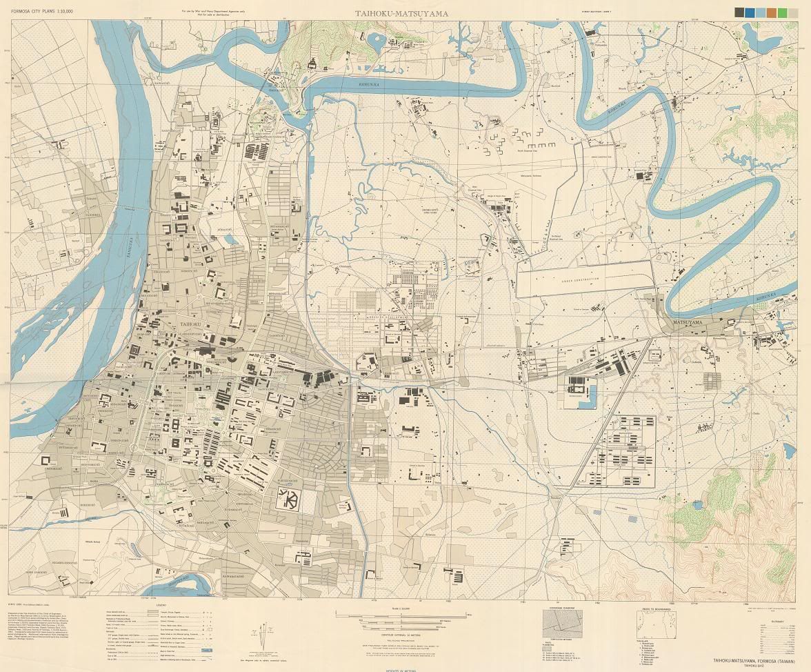
It’s not the most user-friendly map, but it’s fascinating if you’re interested in seeing what Taipei used to be like. It’s also intereting to compare it with images from Google Earth.
Did you know?
Xinsheng N. and S. Road follows the route of an old canal, which explains the odd curve in it.
The diagonal part of Anhe Road that goes past the original Eslite follows the path of an old stream.
Bade Road was a major highway out of the city. It went eastward toward the town of Matsuyama (Songshan), where the Raohe St. Night Market is now. Then it continued on to Keelung.
That curved street in the back alleys to the west of Sun Yat-Sen Memoral Hall was a railroad spur where goods could be shipped to and from a military base where Taipei 101 is now.
There was a brewery near the intersection of Bade Road and the railroad tracks. It’s still there - it’s Taiwan Beer.
The location of Chiang Kai-Shek Memorial was an old military camp.
Yes! You zoom out all the way, then use the Export button. Choose the highest resolution and download it as a TIFF file. It’s about 32MB, but you can see the entire map in decent detail.
I then converted it to a JPEG with 90% compression, ending up with a 4MB file. Very nice.
Thanks very much for that. I think most of the brewery you mentioned is now the Wanhua Art Park (or whatever it’s called). Hope that place lasts a while longer.
Good find chris, thanks for sharing. I noticed an insane asylum near chungshan and Minquan, thats interesting since the new one is behind the LaiLai Sheraton. (LY). Also, I can see the my 12 story building is built on a old pond/swamp. (perfect for liquidfication in an earthquake). Actually, i knew that already, its a risk i know. This metadata on the map says its from USArmy 45. FYI: I posted a smaller version to my photobucket account here if anyone wants a decent size map to check out(264K).
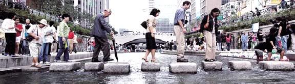
Concerning the old canal in Taipei (still under the freeway). Taipei City should do what Seoul did with the Chonggyechon waterway, convert it into a nice city walkway.
In one of the city’s most ambitious ecological projects ever, the Seoul Metropolitan Government spent more than 360 billion won ($350 million) in the past two years to recover parts of Cheonggyecheon’s original waterways. The stream will open to the public on Oct.1, 44 years after it was covered by concrete amid urban development.
Who knows, maybe Mayor Ma already has this on the drawing board. It would be a good feather in his cap, just like rebuilding Wanhua and Xinyi areas. Its would be nice to see the kmt put a little pride into the city for a change. It took only 50 years to get new sidewalks, but its a start.
a few more: the stream “aka-ike” followed today’s xizang rd and sanyuan street
a railroad ran along dingzhou st
an open portion of the now underground diagonal stream across east taipei can be seen just west of guangfu s rd, first alley south of xinyi (the furniture alley). from there it followed the diagonal alleys north of xinyi, anho rd, the diagonal plazas starting across from anho/tunhua and going behind sogo, then to the diagonal alleys across fushing.
I just read the article by Joseph R. Allen to which 4nr had provided a link in another posting. Anyone (like me) who knows the layout of the city but wants a deeper historical understanding will find Allen’s article very useful. He is particularly illuminating on the ways in which the Japanese filled in the mostly empty rectangle formed by the city walls, which were themselves “an attempt at nostalgic sinification” by the Chinese. Check it out. fas.harvard.edu/~fairbank/tsw/allen.html
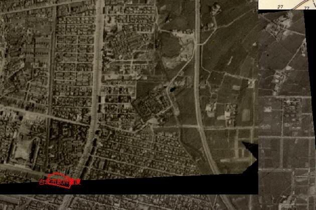
Just checked it out, very interesting. Here is a small snippet looking at nanjing e. rd (middle left) and zhongshan n. rd. you can see the creek in the lower center. its seems the area around was not built up probably due to flooding.
I can’t see it on this map, but it was mentioned the creek now runs underground the dinghao area (plazas located in Chunghsaio section 4/anho rd). i never realized that. I always wondered why they never made those plazas nicer since they are in the center of town/shopping area. i remember long ago there use to be a big brass ball statue, later torn down and replaced with a funky mod-art fountain that never worked/covered with graffitti. Now thats gone too. This maps also shows a good outline where the old city walls were. Thanks for sharing.
Thanks, Atra. A fascinating read. Very informative and stimulating. I found this passage especailly interesting:
He’s referring to Jhonghua [Zhonghua] Rd, of course. Imagine, it used to be part of the old city wall in the 19th century, got turned into a street during Japanese times, and a railroad was put in the middle of it, and now the MRT blue line runs underneath it. Too bad the original west gate is gone with the MRT Ximen (west gate) station as the only reminder of it.
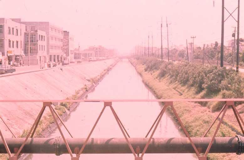
The canal under Xinsheng joins another canal just north of where the old Guanghua Market was. From there you can follow it to the west and south, paralleling Civic Boulevard for a while, where much of it is a park called 瑠公圳公園 (Liugongjun [Liugongzhen] Park). It proceeds across Fuxing S. Rd. behind Sogo, then diagonally across Zhongxiao, making up that diagonal plaza you see there. Then it proceeds past Eslite, along Anhe Road, and then diverges diagonally from Anhe Road to the Guangfu/Xinyi Road intersection. From there the canal narrows and heads southward. South of Furniture Street, it joins another canal flowing from around the Taipei 101 area. Then it goes south all the way to Jingmei, connecting to more canals and the Jingmei River. The whole canal system was called 瑠公圳 (Liugongjun [Liugongzhen] - see the name of the park above), and it was an important means of transporting goods in the olden days.
There are some places where the canal can still be seen. Certainly you can see it under the overpass at the north end of Xinsheng. I wonder how the MRT construction projects deal with it.
One of these days I’m going to walk all the way along it to Jingmei - call it “urban river tracing”. It’ll be good exercise!
You can still see a small section of the canal off Wenzhou St just south of Xinhai Rd (in the neighborhood behind Tequila Sunrise). The place is now a popular spot for bridal photos.
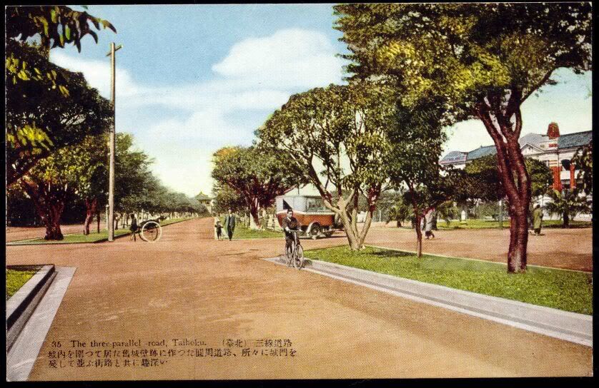
I have a pretty good collection of pics/postcards/maps/etc. that i’ve been collecting over the past few years from from the net. I’ll get around to organizing them into a pdf someday soon and post a link. Here is a pic of one of the three lane roads mentioned in the wall article. I think it is the old RR HQ building to the left and the northgate in the distance (?) can’t really tell. I remembering also seeing a photo of a stream in front of the control yuan, i think circa 1900.
Also, if interested, near exit 8/9 in the metro mall (which are the exits for the red/white/blue airport/keelung bus in front of the train station) there is a display of the foundations of the old city wall. I also remember when they dug up Nanjing rd. a few years ago, you could see they used many of the old city wall stones for the sewer lines.
Today we walked along the old canal, starting from behind Sogo and going to the southeast. We found that there is indeed an exposed section of the canal on Furniture Street, in the alleys southwest of Xinyi-Guangfu roads. The water is flowing northwards. We continued southward, following the canal all the way to Jingmei where it meets the Jingmei River. Good exercise and a beautiful day to do it!
On the way we discovered a neighborhood with some old “san he yuan” near the Tai-Da Campus and adjacent to the Taipei Water Bureau.
Think that is the current presidential palace in an earlier manifestation, with the little south gate in the distance.
cool about the hike, all the way to jingmei! what are “san he yuan?” That reminds me, once i came across a lane with a bunch of old houses. it was on the hills north of heping in the linguang area. i tried a few times but could never find it again. anyone know what i mean?
I suspect you are talking about either Chongde St. as it head up into the graveyard out of Liuzhangli or Heping Road Lane 463 which arcs along some rice paddies. There are brick structures including sanheyuan in both of these adjacent areas. You can get on Lane 463 at the Linguang station or, from the other end, just before the tudigong on Chongde in the heart of old Liuzhangli.
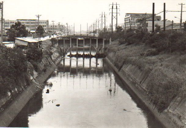
I found these two photos recently on one of the military sites. (link posted in the vintage thread). BTW: There is a new historical marker under the freeway on Nanjing and Chienkou (Jianguo) that tells the history of this area and how this toilet got flushed.
Looking at the old map, the curve of the Keelung river south of the Grand Hotel is still the same, but previously the river took a sharp eastward turn towards where the Shihlin night market is now, then apparently heading northward between chengde/shishang and jihe roads? Anyone know when and how the river came to be in its current position?