From the most unforgettable 2007 experience thread:
I would love for you to start a thread with more details on this[/quote]
OK, here it is, stu.
There are 2 ways to do this: clockwise, which goes from Taipei to Yilan on the beiyi highway (Rt. 9) on the first day, and then day 2 from Yilan to Wulai via Tonghou and then back to Taipei. Or counter-clockwise, which is the same loop in reverse.
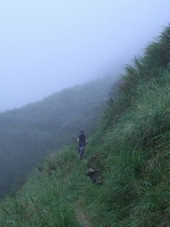
The advantage to the clockwise approach is you can also include the running horse trail (paomagudao), another off-road trail that goes from Rt. 9 down to Jiaoxi, a suburb of Yilan. (You wouldn’t be able to ride paomagudao in the counter-clockwise approach as you’d be going uphill all the way. Unless you’re Lance Armstrong, I wouldn’t recommend it.) Another advantage to the clockwise route is you don’t need to apply for a mountain entry permit as you’ll be entering the trail from Yilan County, which doesn’t have any police outpost at the trailhead like they do in Wulai. And the biggest advantage to the clockwise route is that you’ll be riding downhill on the sweetest offroad sections of Tonghou. And that’s what made the ride so memorable.
Now the disadvantage to the clockwise route is a steep, long heartbreaking climb from Yilan up to the pass where Tonghou begins. But considering all the pluses, it’s well worth it.
[quote=“urodacus”]maps? pics? free beer? C’mon, man, put some effort into it.
(nicely, of course)[/quote]
Hehe. Take it as a compliment, Incubus. I reckon a few people on here are very interested to hear more. Map, pics, of course. Also, how many went, etc.
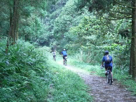
There were 4 of us; 3 men and 1 woman. I don’t recommend riding it alone, at least not the first time.
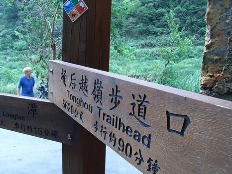
Sorry, no maps. But it was easier to find than we thought. There are clearly marked sign posts starting from as far as 5 k away from the trailhead. We had to ask for directions a couple of times to find Longtan, the last town with a 7-11 before you head into the mountains.
Incubus, if you don’t have maps I can help you out and draw the route on the ones I have. A coupel things to note: buses can now take the No 5 highway (tunnel) so traffic is going to be even lighter on the 9 to Pinglin. That said, you can also get to Pinglin by starting in Muzha and following Muzha Rd to Shenkeng and then the 106 to Pingxi. From Pingxi there are seldom used mountain roads to Pinglin that drop you off high above the river. It’s a great 10km or so downhill all the way to the the town. Lots of cyclists take the 9 but noone seems to take this route.
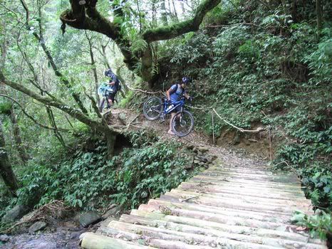
I think every serious mountain biker in Taiwan should ride/push/carry their bike over the Tonghou pass at least once in their lifetime. You’ll be dead tired afterwards but it’s totally worth it.
You can ride it in the winter if you have Under Armour. The higher elevations can get pretty chilly.
We stayed in Jiaoxi, the hot springs capital of the northeast coast. Lots of accommodations to choose from in this tourist-friendly town.
Sure, MM. Put up the map and help the fellas out. The only tricky part was getting from Jiaoxi to Longtan. From Longtan, one can just follow the Xiao Jiaoxi river upstream and will come to the first sign post. The rest will be clearly marked.
I think the reason most cyclists take Rt. 9 is the gentle grade. The mountain roads may have lighter traffic, but they’re also steeper. And when you travel more than 60 km over two major mountains, you’d want to take the flattest route possible.
A couple of weeks ago, I took the bus back from Pinglin to Taipei via the ‘Death Highway’ at about noon on a Sunday and there’s a lot less traffic than before they opened the tunnel route.It’s certainly a lot better for cyclists than it used to be.
As MM sez, there are an assortment of winding and very pretty roads with fabulous open views of the tea farms on the hillsides coming up from Shiding side.They are all well worth exploring. Actually, for cyclists a route going from Taipei to Pinglin via No. 9 Hwy and then using the mountain roads to head ‘upstream’ and then over to either come down to Pingxi or Shuangxi would be an excellent two day work out.
A fabulous detour would be to go to the peak at 840 meters that’s almost due North of Pinglin. It has a pagoda on top surrounded by a little park giving unobstructed views. The farm road turn off goes to a little parking area just short of the peak and after that it’s a five minute hike.My recent hike was from Shifanliao area up and over to the upper reaches of this valley and down to Pinglin. I didn’t camp here, but after bagging the peak I made a mental note of it for another time. There is a water tap and enough space to set up a tent. On a sunny day it’s possible to gaze out a long way over this obscure backwater, get one’s bearings and target new areas to add to the trail network.
That’s right, a hike sans bike is easy, but if you hike a bike over your shoulder for an hour, which is what you’d have to do to make it over the pass, that’s a whole different story.
It could be, depending on who’s in the club. A cycling club attempting to go over the Tonghou pass could also be disastrous. Unless everyone is of similar riding abilities (climbing, off-road, hike-a-bike), at that distance the less experienced riders would inevitably lag behind and cause a delay for everyone.
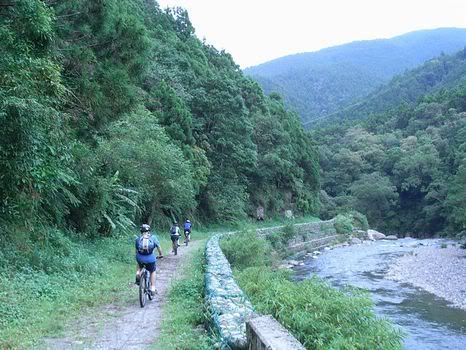
Ride to Wulai and cross the bridge that leads over the Tonghou River to the tourist street. Don’t go down the tourist street but instead turn left just after you cross the bridge. Follow this road all the way to the end, about 15-18 km. 15-18 km. You pass by a police checkpoint where you must register (NT10) before going any further.
The trail begins at the end of this road. It is marked with English and Chinese signs and is obvious. At the other end once you are back on the road, I am not entirely sure how you get to Jiaoshi but just keep going down. Head toward the ocean.