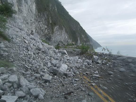
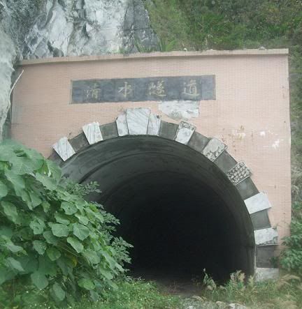
Tommy’s old and now abandoned Suhua road - this part was replaced by the Huide Tunnel. There’s a lot of fallen rock and it’s overgrown here and there but still walkable, hell, I even dragged the bike through it. There’s the 500m long Qingshui Tunnel part of the way along - take a flashlight.
Nice pics. Are people still able to just go on those areas? Not roped off? It was even more amazing then it is today back then. It was awesome but highly unsafe. Im glad I did it. When it was there to do.
Likewise very sorry I never did the Southern Cross when it was there to do . Now it will never be there to do again (at least from one end to the next).
Ditto, im glad i did the E-W cross island when it was also there to do.
Taiwan is a young island geologically speaking and all these types of roads are basically “temporary”.
Mmm, I saw plenty of other no-entry areas, but IIRC this section you’re allowed to walk through. As the pic shows though, it gets a lot of rock fall from the 200m cliff directly above. Take a flashlight and a helmet, perhaps.
Lucky you. I really do not know why I let the SouthernCross get away. Not having been on any stretch of that road ever. Never did the northern cross either. Because the one time i did attempt to do it there was a huge landslide and traffic was being turned back.
Never set foot on Green Island, Orchid Island or the other tiny islands of the pescadores or keelung islet or turtle island (both of the latter now open I believe).
At the rate of change, I may later have to say “no, never been to Taiwan”
p.s. one time in Wulai I came upon a restricted road that lead into the mountains and one had to get a police permit to enter. Which I did. And i heard that there was a road planned from that area over to the east coast. Did this road ever get built? And if so whats the road number? Or was the idea abandoned?
I’ve been up there. I’ve heard the same rumor about a road that would eventually lead to the No. 7. The road leads to the Atayal village of Fushan. It goes beyond there, but then just ends.
The time I went was when we did a hiking trip to the Hapen (Hbun) Trail. Starts just beyond Fushan. Then you can hike it all the way to Yilan: the trail ends in a botanical garden area. But when we went it was pretty miserable: raining, lots of leeches, and there were a couple landslides we had to deal with.
According to the information of the Highway Disaster Information System http://bobe.thb.gov.tw/DefaultGeneral.aspx?queIndex=1 the Southern Cross-Island Highway will be opened at the end of the year. Anyone knows whether this is likely or not?
I got the required police permit and walked up the first 4.5 km of this road on my first day in Taiwan (kind of an epic exploration, really, for someone fresh off a plane; I’m still pleased with myself). It was a gorgeous walk but I saw no evidence of it hooking up with any kind of “major” road, though I’m also sure that I did not go far enough to actually see such a junction. I’m just guessing that it’s not connected based on the traffic I saw, which consisted of three cars and maybe ten scooters in three hours.
Hard to say. Richard from Barking Deer Adventures has told me he’s been hearing it will reopen. He’s pretty in touch with things on the ground as he’s constantly out talking to people at the national parks, scenic areas, etc. I’d say there’s a good chance now. It’ll be so messed up though that few cars will attempt it. Meaning it will be perfect for cycling.
no the roads in Wulai don’t go all the way to the coast. The one that follow the Tonghou River left when you enter Wulai village ends at a National Trail which does take you over to the coast but you have to walk or mountain bike.
The South Cross Island is one of the most beautiful drives I’ve ever seen anywhere. Beats any road that I’ve driven in the Canadian Rockies. Put the scooter in neutral, coast back down, near silence, and no need to even turn on the engine for an hour or so. Bliss.
(Although I’d still take the Rockies for hiking. Hiking off the South Cross always seemed oddly pointless: “I’ve already got this view - why bother?!”)
This guy biked it recently. Lots of damage to the road, but if they can reopen the Su-Hua they can reopen this. Just be aware that the danger is not going to be gone. Just delayed till the next rain/earthquake.
It’s not a question of can it be done. Of course it can. But is it good policy and is it sustainable or just a big drain on the nation’s coffers? No one lives on the SC. There’s little need to have it.
Thats true, unlike the Su-Hua. But maybe the same level of work is required to bring it up to a bike path standard as to reopen as a two lane. So may as well. Otherwise the SouthCross is dead forever.
this guy biked it recently. Lots of damage to the road, but if they can reopen the suhua they can reopen this. Just be aware that the danger is not going to be gone. Just delayed till the next rain/earthquake.[/quote]
If that one slide is the worst of the damage, any 4x4 or heave blue truck could make it. The road is probably open to local traffic already.
I know someone who was down there maybe a week and a half ago. Said that you couldn’t go the the way through, but it was just a short stretch that wasn’t passable. He went in from both ends and covered most of it (although with a 4wd).
About the old road that goes over the hills from Wulai to Ilan, it actually went from just past the village on the TongHou Stream (Hsiao Yi I think it’s called) and went around a low point on the ridge north east of the nearby peak at 1420 meters. About 15 years ago, it had already deteriorated to a hunting track, very overgrown with saw grass and other secondary growth, but the waterlogged surface was a prime spot for foraging wild pig that I bumped into a couple of times.There were still a few mileage signs rotting in the damp forest. I got in about 8kms from the village and just short of the ridge line.
On a subsequent trip to hike the peak, a long day hike, I did as before: I turned right off the main TonHou route to Ilan onto a dirt road heading south from the village. After a kilometer there is a bridge over a side stream (and where the bushwacking began) and on the right turned off onto the hiking path up to the peak and came down to the other side rejoining the remnants of the road which came down near the FuShan botanical preserve entrance.
It’s completely overgrown now and I have no idea if this was used by regular traffic or was for the exclusive use of the forestry department or camphor extractors.
I heard the Suhua Hwy was closed again by a landslide near Dong’ao. We’ll be coming to Taiwan next week and driving down this road on New Year’s weekend. It doesn’t sound like a big one but it will definitely make me a little nervous driving there. Hopefully the rain stays away then!