Anyone knows the way to Xiao Wulai?
Leaving Taipei center with a motorbike.
You know it’s the place with these very very old huge trees.
Thanks.
[quote=“igorveni”]Anyone knows the way to Xiao Wulai?
Leaving Taipei center with a motorbike.
You know it’s the place with these very very old huge trees.
Thanks.[/quote]
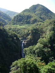
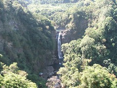
No, Xiao Wulai is the place with the fabulous waterfall. There is a strand of old trees, but I believe it’s quite a hike from the falls.
You should take the number 3 provincial highway all the way down past Sanxia. A little ways past Sanxia you’ll see a sign on the left to reach Dongyenshan Forest recreation area. Turn and this road will drop you off on the number 7 just past Fuxing.
Xiao Wulia is a few kilometres east just past the 20.5 kilometre mark. Turn left, there is a sign in Chinese, and drive up the road a kilometer to the entrance gate. Pay and on the other side you’ll see the falls.
Here are pics:
robert1566.fotopic.net/p4490123.html
robert1566.fotopic.net/p4490127.html
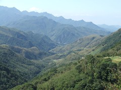
I believe Taipei Day Trips II lists a trail from Dongyenshan (or is it Man-yueh-yuan Forest Rec Area) that leads to the old trees. But it’s a long walk. Anyway, Dongyenshan is a lovely area. Nice hikes and gorgeous bamboo covered mountains.
If you’re going to stay for a couple days in the area the Youth Activity Centre in Fuxing is excellent. The rooms are spotlessly clean, newly furnished and quite large. The centre is on the site of an old Chiang Kai Shek villa. Gorgeous views from the back rooms and the coffee shop has a picture perfect panoramic view from the deck. From the parking lot you can hike down to a branch of Shiman Dam and go swimming.
I wonder if you’re thinking about the strand of old trees at Lalashan (Upper Baling).
Well, I was talking to that guy at the Taipei hikking Ass. and he said there were these huge trees in Xiao Wulai 2000 years old, and the waterfalls etc… Do you see what he meant?
He said it was roughly a 2 hours motorbike ride.
This is a one day trip for Sunday. Leaving at around 6 in the morning.
No old growth forest in Shaio wu lai?..
Not only are there 2,000year old cypress trees in Shiao wu lai, they are possibly even more beautiful then their La la Shan counterparts…
Sanming to Shiao wu lai:
When you come up from Sanshia you’ll end up in the town of San-ming, turn left towards Fushing. It’s a pretty windy 5km or so to Fushing, and you’ll end up at a three-way intersection at the top of a hill. Keep going straight and the road will start down into the river valley (careful for the very windy last two or three corners at the bottom!). Once at the bottom, (about 2km), you’ll be hugging the hillside on the left hand side of the valley. Once on this section of road it’s only 3km or so to the turn- off. You’ll pass some houses, a major cliff slide (Typhoon Nari) and then after 3 or 4 corners you’ll see another river tributary running into the main river with a small white bridge crossing it. Go over the bridge, the road will take a sharp right and then a sharp left…Directly after the end of the sharp left is the Shiao wu lai turnoff on your left and up. You’ll be able to see a police station on your right after you turn. From there it’s about 3km to the tollgate.
If you miss the turnoff you’ll end up on a large red bridge after about 300meters…No biggie, just hang a U-turn and look for the first very sharp right hand turn going up.
Ok, this next part is important…The old growth forest is not in the tourist area of Shiao wu lai!
Pay your 60NT and check out the waterfall…It’s only about 150 meters or so past the toll both, and it’s spectacular. There is also an observation deck down to your right.
Now to the old growth forest:
Continue up the road for just 150 meters or so and you’ll see a left and a road heading down and to the left. Take the left hand fork (The road heading down leads to the main Shiao wu lai parking lot) The left hand fork will take you straight through the main village (up a rather short but steep hill). Continue through the village. About 200meters past the last house, the road will split again with an upper and lower fork. Simply take the upper fork and follow it to the end (It’s a fair distance, and very steep). The trail head begins at the parking lot. Hope you are in good shape, it’s one hell of a hike!
Thank you very much for taking the time to write this post. i really appreciate your time here. thanks a lot.
Hmm…That scares me a lot. Please define “one hell of a hike”
Is it all stairs? I am going with my 7 years old, he is a fairly good hikker but would that be just too hard for him?
[quote=“igorveni”]Thank you very much for taking the time to write this post. I really appreciate your time here. thanks a lot.
Hmm…That scares me a lot. Please define “one hell of a hike”
Is it all stairs? I am going with my 7 years old, he is a fairly good hikker but would that be just too hard for him?[/quote]
Bring lots of water, and some chocolate for your boy and you’ll be fine. If he hikes anything like my 11 year old daughter, he’ll likely run you into the ground first.
As for the trail…Some stairs, but not too many, mostly cut trail and roots for steps. Trail is steep and overgrown in places. Expect to be ducking under fallen trees and watch out for trail damage/slides from the last Typhoon/today’s quake. Also, watch out for snakes.
It’s been a few years since I’ve been up there, but you’ll need a couple of hours to get to the strand of older trees. If your 7 year old can’t hack the hike, come back down and access the river. You can take him for a swim, that’ll rejuvenate him in a hurry.
The whole area is very scenic, and the both of you will have a great time…Enjoy!
MJB, thanks for posting the directions to the trailhead. I knew there were old trees, just not near the waterfall. Do you by chance know how to hike to the hot spring that was discovered in that area last year?
If Igor is coming from Taipei he doesn’t need to drive all the way to Sanmin and then to Fuxing. Just past Sansia (Sanxia) get on the number 3 spur route (it has a 3 with that squiggle underneath that looks a bit like a Z) which goes almost due south while the #3 goes south-west to Daxi. The road will narrow and ride beside a flowing river. You’ll see a sign pointing left to Dongyenshan Forest. Take it and you’ll drive through the mountains and end up just past Fuxing on the number 7. Turn left and continue a few kilometres to the Xiao Wulai turnoff.
Last time I drove to Fuxing (May) there was a lot of road construction just past Sansia so taking the route to Dongyenshan is better. Also there is less traffic and you can stop in the park headquarters and check out the hikes they have there.
Oh, just read that you are leaving at 6am. Maybe you don’t want to take the cutoff as there may be fog at the higher altitudes and it will be chillier.
[quote=“Mucha (Muzha) Man”]MJB, thanks for posting the directions to the trailhead. I knew there were old trees, just not near the waterfall. Do you by chance know how to hike to the hot spring that was discovered in that area last year?
If Igor is coming from Taipei he doesn’t need to drive all the way to Sanmin and then to Fuxing. Just past Sansia (Sanxia) get on the number 3 spur route (it has a 3 with that squiggle underneath that looks a bit like a Z) which goes almost due south while the #3 goes south-west to Daxi. The road will narrow and ride beside a flowing river. You’ll see a sign pointing left to Dongyenshan Forest. Take it and you’ll drive through the mountains and end up just past Fuxing on the number 7. Turn left and continue a few kilometres to the Xiao Wulai turnoff.
Last time I drove to Fuxing (May) there was a lot of road construction just past Sansia so taking the route to Dongyenshan is better. Also there is less traffic and you can stop in the park headquarters and check out the hikes they have there.
Oh, just read that you are leaving at 6am. Maybe you don’t want to take the cutoff as there may be fog at the higher altitudes and it will be chillier.[/quote]
I haven’t been to the hot springs…yet. Our excursions to Shiao wu lai usually consist of river hiking and swimming.
I like your alternative road suggestion, and you are right the road construction around Sanshia is ongoing. We’ve always accessed Shiao wu lai from Shrmen or Kuanshi if the traffic is bad. I’m far enough south that I can rip around the backside on the 118 (Kuanshi to the Beihun entrance) in about an hour and ten minutes. During the week it’s only about an 50 minute drive following the usual Shrmen-Tzuhu-Sanming-Fushing route.
It’s 11km from the 7 to Dongyenshan…What’s the drive like from there back to Sanshia? If it does follow the ridgeline as I suspect it does, the views should be fantastic. It’s been really clear down here, windy with a morning chill. Perfect riding weather. You can actually see the Dongyenshan ridgeline from my neighborhood on a clear day.
I’ll try to find out some info on the hot springs next time I go up and post back.
I went up to Fuxing on Sunday to scout routes to the big trees at Xiaowulai. As mentioned in earlier posts, the route from Xiaowulai is closed. The police at the toll booth were pretty firm about denying entry to a hiker trying to get to the big trees.
Backtracking, I went to the park at Dongyanshan to investigate whether it is feasible to get to the trees from there. It seems to be possible, but I didn’t have time to do it. Here’s what I did have time for:
Hiked all the way through Dongyanshan park, along the gravel road past the fossil area (3.7 km) and onto the trail at the end of the road. From there, followed the well-maintained trail for appx. 4.5 km to a trail junction at a pass. The trail down on the left heads to Manyuehwan (sp?), the park (with waterfall) accessible from the Sanhsia side of the ridge. According to the sign, it is 3.5 km down to Manyuehwan from the junction. Heading up the fork on the right takes you toward Beichatienshan, another 5.7 km.
About 1 km up that trail from the junction, a marked trail ascends up the hillside on the right. This trail goes to Xiaowulai. There is a sign stating that fact, so just keep your eyes open. It was getting late, so I only pushed another 1 km or so along this trail before stopping to snack before turning back.
While resting at a creek crossing, I met a group of four hikers coming along the trail who claimed to spend every weekend on the mountain. They were returning to Xiaowulai. I told them I had tried to come up from Xiaowulai, but that the police had denied me access due to the wrecked road. They agreed that the road was closed, but indicated that they had come from there the day before and had spent the night on the mountain. Unfortunately, I didn’t have time to ask them about the distance to the trees or the trailhead from our location before they pushed on down the trail. The time was then 1:30 P.M., so I figure it could not have been more than three hours to the bottom (unless they were planning to hike in the dark). From where I stopped, it was a fast two-hour hike back down to the tollbooth at Dongyanshan Park.
Has anyone come up to the junction below Beichatienshan from the Manyuehwan side? What is the distance? Is it a shorter walk than coming from Dongyanshan? Have you been down the trail to Xiaowulai, or to the trees from there? And what about the hot spring?
Information would be appreciated.
Some nice photos of Xiao Wulai in this thread, but of the others…Luhkang and some other piles of brick. Why does it seem like anything that is not covered in bathroom floor tiles in Taiwan gets photographed?
[quote=“timogan”]
Has anyone come up to the junction below Beichatienshan from the Manyuehwan side? What is the distance? Is it a shorter walk than coming from Dongyanshan? [/quote]
The sign posted at the junction is accurate - it’s about 3.5 to the waterfall and 5km to the parking lot. The vast majority of people approaching Beichatienshan do it from this direction. Yes, it’s much shorter, especially if the gate on the Dongyenshan gravel road is closed (as is almost always the case). I’m afraid I can’t help with directions to the old trees or hot spring. Any “experts” care to help? 
I can’t help with the hot spring or the trailhead…
Just wanted to inform everyone interested that they plan to open the road into Shiao wu lai in about 2 weeks.
Sure would have liked to have been up there today… 
I guess I’m the only one who’s heard of the hot springs. I learned about it from a local aboriginal in Fuxing. Seems the spring appeared after an earthquake a year or so ago. The people at the tourist centre in Cihu confirmed the existence of the spring but only said it was in the mountains around Xiao Wulai. The owner of the land has not decided yet what to do about it.
I know about the hot springs…Just the people are being rather tight lipped about it. When the road reopens I’ll go up and take a look.
Tight lipped is right. Hope you can find it. But since it is on private land what are the chances of free bathing?
[quote=“timogan”]
According to the sign, it is 3.5 km down to Manyuehwan from the junction. Heading up the fork on the right takes you toward Beichatienshan, another 5.7 km. About 1 km up that trail from the junction, a marked trail ascends up the hillside on the right. This trail goes to Xiaowulai. There is a sign stating that fact, so just keep your eyes open. It was getting late, so I only pushed another 1 km or so along this trail before stopping to snack before turning back. [/quote]
Got some information yesterday. I don’t know the distance, but according to a friend the walk to the big trees is about an hour and thirty minutes from the sign. He also claims that because of the changes in elevation starting in Dongyenshan is the easiest of the three routes. From the toll gate it’s roughly an eight hour day hike.

Great map chung!
My friend “Z” made the hike a couple Sundays ago and he said it was a 12-hour round trip, but well, well, well worth the effort.
Actually, he said it could have been done faster, but the group he was with (a mixed group of adults and kids) took frequent stops up and back.
Something for a dry Sat. or Sun. in the near future for sure!
I visited the waterfall last month. I went by motorcycle. The route from Sanxia to Fuxing is fairly easy to follow.
You can read more about the waterfall on my blog. There is lots to see in this area apart from the waterfall. I also wrote about another trip to Fuxing.
Here are some photos: