This thread got me reading some of the alleged documentation of Taiwan through out Chinese history. I’ve read them all before, but this time around, I’m armed with a much improved Taigi reading skills and rudimentary understanding of reconstructed Middle Chinese pronunciations.
This is what the Book of Sui has to say about how to get to Ryukyu (流求).
In 605 C.E., during spring and autumn, when the weather was nice, navy officer He Man (何蠻) reported that there seemed to be smoke raising from a least a couple thousand Li away when they looked eastward into the sea. Emperor Yangdi ordered general Zhu Kuan (硃寬) to sail into the ocean to find out what’s out there in 608. Since He Man was the one reported it, he tagged along. They eventually reached Ryukyu, but since they didn’t speak the language, they abducted one man and returned.
In 609, Emperor Yangdi sent an envoy to demand submission and tribute. The Ryukyuans refused. Zhu Kuan only brought back their clothes and armour. At the time, Kingdom of Wuo (倭國, present day Japan) sent their ambassador to pay tribute, and saw the Ryukyuan clothes and armour, to which the Japanese ambassador said “this belongs to those living in the kingdom of Yiyejiu (夷邪久國, li-jia-kiu is probably closer to the pronunciation at the time of writing, which seems like another rendering of Ryukyu).”
The following year, the emperor then sent general Chen Leng (陳棱), and advisor Zhang Zhenzhou (張鎮州) to take an army and set sail from Yi’an (義安). They first arrived at Gaohua island (高華嶼, ko-hua su should be closer to the pronunciation at the time of writing), after another 2 days eastwards they got to Xi-bi island (郤鼊嶼, kiok-bi su should be closer to the pronunciation at the time of writing), and it took them one more day to Ryukyu. At first, since Chen Leng enlisted people from the southern kingdoms, there was some black people who could understand Ryukyuans. After the interpreters delivered the demands of submission and tribute, Ryukyuans still refused. They turned on Chen Leng and his men, and Chen Leng fought back, sacking their capital, decimated their army, burnt down their palaces, and captured a thousand man and woman. After they returned to Sui, there had been no more contacts between Sui and Ryukyu.
大業元年,海師何蠻等,每春秋二時,天清風靜,東望依希,似有煙霧之氣,亦不知幾千里。三年,煬帝令羽騎尉硃寬入海求訪異俗,何蠻言之,遂與蠻俱往,因到流求國。言不相通,掠一人而返。明年,帝復令寬慰撫之,流求不從,寬取其布甲而還。時倭國使來朝,見之曰:「此夷邪久國人所用也。」帝遣武賁郎將陳棱、朝請大夫張鎮州率兵自義安浮海擊之。至高華嶼,又東行二日至郤鼊嶼,又一日便至流求。初,棱將南方諸國人從軍,有昆侖人頗解其語,遣人慰諭之,流求不從,拒逆官軍。棱擊走之,進至其都,頻戰皆敗,焚其宮室,虜其男女數千人,載軍實而還。自爾遂絕。
The book of Sui mentioned 4 location names during their voyager:
Yi’an (義安), present day Chaozhou (潮州), Guangdong, is where the fleets set sail.
Gaohua island (高華嶼), ko-hua su should be closer to the pronunciation at the time of writing, unidentified.
Xibi island (郤鼊嶼), kiok-bi su should be closer to the pronunciation at the time of writing, unidentified.
and finally,
Liuqiu (流求), liu-ɡiu should be closer to the pronunciation at the time of writing, unidentified.
If we can find out the identity of any of the islands mentioned in the document, it should help us identify where Liuqui is in the Book of Sui. A lot of scholar who insist on the Book of Sui’s Liuqiu being Taiwan argues that the second island is the Penghu island proper, because there’s a tiny village called Ku-pih mountain (龜鼈山), present day Kue-bi-shan (奎壁山). However, that’s one tiny village on the Northern corner of Penghu. It is highly unlikely that it had such a name back in Sui dynasty, much less representing the entire Penghu proper. As such Liuqiu-is-Taiwan supporter argued that it could be referring to one of the Penghu islands, but there’s even less proof.
I decided to reference how people get to Ryukyu (the actual one) later in Chinese history:
In the book Shunfeng Xiangsong (順風相送), written between 1570 to 1639 (European sighting of Taiwan happened in 1544), offered 6 possible routes to Ryukyu from 4 different ports. The fifth route is the relevant one:
From Fuzhou (福州, present day Fuzhou in Fujian province) to Ryukyu (琉球)
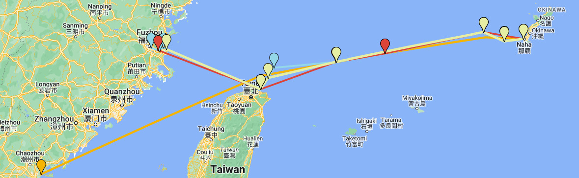
When South wind comes, sail out into the ocean from the port of Meihua, (梅花, present day Chang-le city (長樂市), in Fuzhou, Fujian Province). Take a 112.5° heading to Xiaoliuqiu (小琉球, present day Taiwan). Take a 105° heading to the south of Diauyuyu (釣魚嶼, present day Senkaku island). Take a 90° heading (east) for Chikanyu (赤坎嶼, present day Taishoto). Take a 45° heading (Northeast) to Kumeidao (枯美島).
「福州往琉球」
「正南風,梅花開洋,用乙辰取小琉球。用單乙取釣魚嶼南邊。用卯針取赤坎嶼。用艮針取枯美山。」
During early Ming dynasty, there was a ban on marine-time activities. Only the Kingdom of Ryukyu was allowed to do business with the Ming government, so people of Ming know what they are talking about when it comes to sailing to Ryukyu. So the mystery is where is this "Kumeidao (枯美島), the final stop before Ryukyu? As it turns out, the names of these islands haven’t changed much, today that island is called Kume-jima (久米島), just west of Okinawa proper.
Other navigation books of the time documented a similar path to Ryukyu, such as in Zhinan Zhengfa (指南正法), written around 1685 (Early Qing dynasty):
“Compass needle headings from Fuzhou to Ryukyu”
Sail from Meihua, take a 112.5° heading for 14 hours to Kuilongchang (圭籠長, present day Jilongyu, Taiwan). Take a 127.5 heading for 6 hours to Huakanyu (花矸嶼, present day Huapingyu, north of Taiwan, Hue-kan-sū in Taigi). Take a 90° (East) heading for 6 hours just past the north of Jiaoyutai (釣魚台, present day Senkaku island). Take another 90° (East) for 8 hours to the north of Huangweiyu (黃尾嶼, present day Kuba-shima (久場島)). Take a 82.5° heading towards Kumeishan (枯美山, Kume-jima (久米島))
「福州往琉球針」
「梅花開舡,用乙辰七更取圭籠長。用辰巽三更取花矸嶼。單卯六更取釣魚台北邊過。用單卯四更取黃尾嶼北邊。甲卯十更取枯美山。」
So we have multiple accounts of using Kume-jima just west of Okinawa proper as a navigational way point to Ryukyu. Let’s reexamine the Book of Sui’s Xi-bi island (郤鼊嶼).
According to the Record of Ryukyu Kingdom (琉球國志), by Qing dynasty’s Zhou Huang (周煌), 1714-1785:
According to the Book of Sui: " In 604 C.E., Emperor Yang sent general Chen Leng (陳棱) to sail out to sea. The fleet first arrived at Gaohua island (高華嶼, kau-hua su should be closer to the pronunciation at the time of writing), after another 2 days eastwards they got to qu-bi island (□鼊嶼, kù-bi su should be closer to the pronunciation at the time of writing), and it took them one more day to Ryukyu."
It is also mentioned in Ming Yitongzhi (明一統志, originally called 大明一統志, was compiled in 1461) that "Yuan-bi island (黿鼊嶼, guân-bi su should be closer to the pronunciation at the time of writing) is west of Ryukyu kingdom, and takes 1 day to reach by boat. Gaohua island (高華嶼), also called Gaoying island (高英嶼, ko-in su should be closer to the pronunciation at the time of writing), is also west of Ryukyu kingdom, takes 3 days by boat. Both places are without a name now.
臣按「隋書」:『大業四年,煬帝遣武賁郎將陳棱浮海,至高華嶼;又東行二日,至□鼊嶼:又一日,至流求』。「明一統志」亦云『黿鼊嶼,在國西,水行一日;高華【一作英】嶼,在國西,水行三日』。今皆無其名。
So Zhou saw two other different ways of writing the island’s name than the version of the Book of Sui we have today. It’s clear that
郤鼊嶼 = □鼊嶼 = 黿鼊嶼.
Forumosa can’t display the first character of □鼊嶼, that character is form by 句 on the top and 黽 at the bottom, and is supposed to be an alternative form of 䵶.
According to classical dictionaries:
郤: 《唐韻》綺戟切 (khik)《韻會》《正韻》乞逆切,音隙 (khiok). 《正韻》音其虐切 (kiok)
䵶: 《唐韻》其俱切 (ku). 《集韻》權俱切,音衢 (khu). 《廣韻》《集韻》居侯切,音鉤 (kau). It means a smaller green sea turtle.
黿: 愚袁切,音元 (guan). 《廣韻》五丸切 (guan). 《集韻》五官切,音岏 (guan). 又《韻補》虞雲切,音輑 (gun). It means a larger softshell turtle.
All transcription points to Ku*-bi as the island’s pronunciation, and they all refer to Kume island (久米島). The island got it’s name from Ryukyuan language, and when the people of Kume island visited Japan for the first time in 714 C.E., they called themselves Gubi (球美), according to the Shoku Nihongi (続日本紀).

So if the last stop to Ryukyu in the Book of Sui was Kume island, Ryukyu in the book of Sui can only be the actual Ryukyu, Okinawa proper. The Book of Sui also serves as proof that at one time life of Ryukyu was similar to other Austronesian cultures, at least the Skull rack part.
Four nearly identical routes from the Book of Sui, Shunfeng Xiangsong, Records of Envoy to Ryukyu, and Zhinan Zhengfa:
Resources:
All 6 routes from different ports in Fu-zhou to Ryukyu as documented in Shunfeng Xiangsong.
See all route from this google map page:
google.com/maps/d/edit?mid= … sp=sharing


