I know and it is alway wonderful to see how much this effects on the fisherman all along the rivers.
I guess if the guy would have been there and even started to argue about loss off face and retributions than he would have been expiriencing a loss of face, litteraly meant. He was clever enought to not show up, not sure if he wasn’t there or if he hided as a almost 2m tall and 1xx kg was crawling trough the river, loud swearing and calling names.
@MJB: thanks for your services, you should really go into translation service industry or into teaching english business…
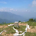
The trig points are stone pillar for surveying. Investigators need best prospect for measurement so the locations of trig point usually provide best view from mountains. That’s the reason that some hikers and mountain climbers go after trig points.
There are four degrees of trig points defined in Taiwan. The average length of the side of first-degree, second-degree, third-degree and fourth-degree trig points are 45, 8, 4 and 2 kilometers respectively so the first-degree trig points provide the best prospect from mountains. The number of first-degree trig points in Taiwan is 83 and 228 for second-degree, and the number of third-degree trig points is 1055.
Euh … I know off some gps markers in Sanxia not trig points … these are short wooden poles with the gps mark on it, somewhere along the trail not in plain sight on top of mountain or visible from far …
I prefer to explore new trails and cut through bushes and awns than staying in lab and library. (I got long reading lists from professors and have been designated to conduct some experiments… )
[quote=“Muzha Man”][quote=“kate.lin”]WOW! It seems an “EXCITING” hiking event. If I were there, I would enjoy it fully with tears.
Will we revisit Wuliaojian soon?
(asking with a shivering voice)
[/quote]
It’s a standard late fall hike. It’s also my favorite and a lot of other HC members favorite. No question we will do it.[/quote]
Ach! The hubris! The cheek! I’ll have you know, young feller - north of Sanxia there’s still quite a bit more “north” to trample around in - the locals call it the Yangmingshan Range…little known, hard to find, but well worth the effort
In terms of sheer visceral excitement, though, Wuliao Jian is indeed hard to match. I almost soiled my knickers on that knife ridge…
Ach! The hubris! The cheek! I’ll have you know, young feller - north of Sanxia there’s still quite a bit more “north” to trample around in - the locals call it the Yangmingshan Range…little known, hard to find, but well worth the effort [/quote]
Clearly you haven’t experienced a trek up the Yu Nei Stream to the summit of Beicha.
I received email from my professor which notified me to summit a report after the Chinese Mood festival and she attached a damned long reading list as my reference.
Geese! I suddenly became a report slave that only produced nonsensical discussion about human brain function. I was eager to get out of the limbo so I spent two days and nights to finish it and that almost made me brain dead.
I finished my report last night and I went hiking directly today.
I went Maokong in Mucha in the morning and enjoy a nice lunch there and I went Lionhead Mountain in the afternoon. Both activities were actually nice walking in the woods.
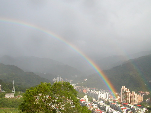
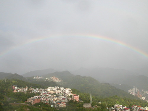
And I saw double rainbows on Lionhead Mountain and the rainbow was in the beautiful arc that I could see both the start and end points of it. That was fabulous.
Tomorrow is the last day of the holiday. I will go to Tianmu Trail. According to a website, it is a trail of Monkeys. I mean monkeys sometimes will show up and attack hikers for food. Mm…it sounds fun. Go Monkey Trail!
I’m wasted … did my 5 km power hike this morning and went up Yuanshan this afternoon around 2:00PM … did about 4 hours … can’t feel my legs anymore … made some pics on the away and will post them later on, perhaps tomorrow
I went to Tianmu Trail this morning and expected to see monkeys waiting for me on the trail. It seems I didn’t get there early enough so monkeys were gone.
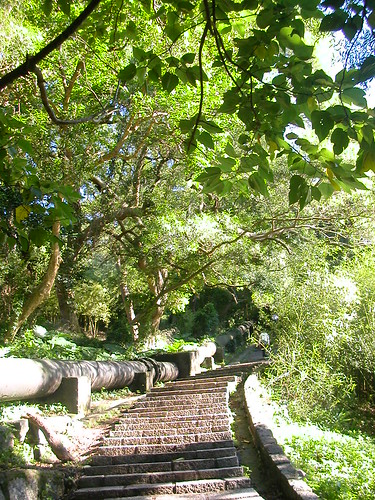
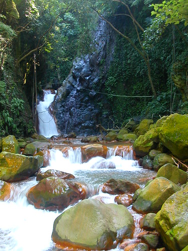
The entry of Tianmu Trail is located at the end of Zhongshan N. Rd., and it’s really easy to find it. The first section of this trail is a one-kilometer stairway to the ancient Tianmu Trail and the second section of the trail is the ancient Tianmu Trial which a lovely 1.8-kilometer tree-tunnel trail. The shadow of trees and the breeze from the valley are great enjoyment. The third section is the trail leading to Cuifeng Waterfall. The stream down to the waterfall region is full of sulfur so the water isn’t transparent, and the stones of the stream are all red. Spending a morning lying one rock and enjoying the nature is splendid!