June already - and the first one might be brewing:
Current Windy prediction:
Touch wood. The last 2 years have been the worst ones I’ve ever seen, wind wise.
Be the change.
But who then will be the alarmist? ![]()
On scale*
I don’t know.
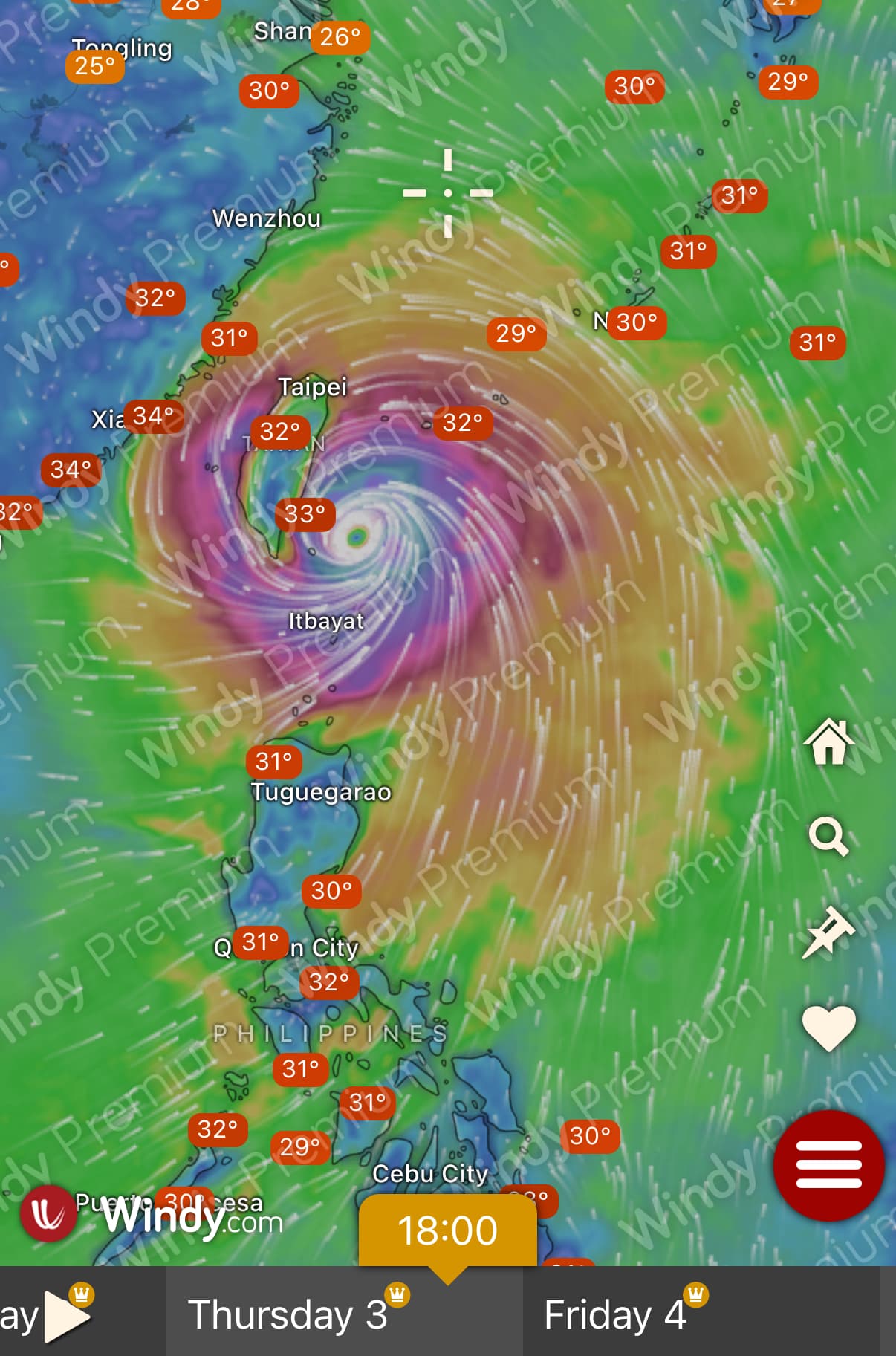
While the storm will not directly impact Taiwan, it will push the entire low-pressure belt northward, Kuan said. As a result, Taiwan is expected to be impacted from Wednesday.
According to Central Weather Administration records, this is the latest in the year that a Pacific storm has formed since 2016.
First real rain I’ve seen in this spot this 2025 year. And, we are flooded!
【高市府公告】
根據中央氣象署資訊,受到熱帶性低氣壓影響,山區雨勢持續增強,有致災之虞,為維護民眾安全,市府宣布那瑪夏區今(6/13)日自中午12時起停班停課。
【Announcement from Kaohsiung City Government】
According to the Central Meteorological Agency, due to the influence of tropical depression, the rain in mountainous areas continues to intensify, and there is a risk of disaster. In order to protect the safety of the people, the city government announced that the Namasia District will suspend work and classes from 12:00 noon today (6/13).
Flooding in Kaohsiung. Suspension of school and work in certain areas due to floods and heavy rain. Fuxing Village, Lafulan Village, Meishan Village, Baoshan Village and Taoyuan Junior High School in Taoyuan District, Maolin and Namasia.
I continue to miss the old distinction between Kaohsiung City and Kaohsiung County.
Hope everyone is safe down there.
Yeah, those places are mostly mountains a few hours away from the “city”
Mostly friendly Indigenous up there, I also hope they are ok. Lucky the earthquake came before the ground got so much water
Meanwhile, the weather agency said a tropical depression located over the sea south of Japan strengthened into a tropical storm at 8 a.m. to become the second tropical storm over the western North Pacific this year.
The CWA projected the storm, named Sepat, will move in a northwesterly direction toward Japan, and have no direct impact on Taiwan.
So far, a really quiet season for Taiwan.
It’s not Windy, its the ECMWF projection, one of the several Windy can show (you can select the various models in the settings bar in the Windy app).
Most predictions agree that there will be a tropical development around Guam next week, but the projected paths are all over the place.
If a High Pressue Area develops further, the TD or typhoon will most likely move to the north without impacting TW at all.
If not, a western path is most likely.
That said, ECMWF is pretty good in its predictions once a system is formed, so there surely is a chance.
The Central Weather Bureau said Thursday that a tropical system near the Philippines will strengthen into a tropical depression as soon as Friday, bringing rain across Taiwan.
Localized heavy rain is likely in central and southern Taiwan on Friday, while sporadic thundershowers are expected in the eastern half of the country, areas south of Hsinchu County, and mountainous regions, CWA forecaster Chang Cheng-chuan (張承傳) told CNA.
[…]
Chang said the current tropical system is expected to approach Taiwan this weekend and may intensify into Typhoon Danas.However, he noted that current environmental conditions are not favorable for development, so the extent of its strengthening remains uncertain.
The system is projected to move westward on Thursday and Friday, and then turn northward on Saturday. It remains uncertain whether it will pass along Taiwan’s east or west coast, or make landfall.
Note that the article image is misleading - they’re not talking about tropical storm Mun (which is near Japan), but about that one (tropical depression 98W):
Here in the North, it was already quite windy today (at least compared to the previous days).
Damn. Coulda used a Typhoon day today
The Taiwan Weather Bureau has started tracking it too under the name TD06:
The system is expected to shift direction later Saturday toward the north or northeast, and is expected to pass closest to Taiwan between Sunday and Monday morning, with a high likelihood of passing over the Taiwan Strait.
Heavy rainfall is anticipated on Sunday, especially in southern and southeastern mountainous areas, while other regions may experience localized downpours.
Lee cautioned, however, that the system’s path remains uncertain and should be closely watched.
Independent meteorologist Wu Der-rong (吳德榮) also warned Friday that the storm’s most severe impact is expected between Sunday and early Monday, and he stressed that “the threat to Taiwan should not be underestimated.”
Imma go river tracing tomorrow