August 6 Hike: Up the Creek in Daxi

Sorry to hear you’re dropping out of the hike, MM.

With Mucha_Man dropping out of the hike, I’ll volunteer to lead the hike, or if seeker4, ratlung or trail_hacker want to lead (or co-lead with me) that’s fine too, since we’re all familiar with that river. In any case, I’m determined to make this hike a success, so the hike is still on unless the weather’s bad.

I’ll be in touch with Mucha_Man about directions and other details.

We meet at 8:00am at Mucha MRT Station Sunday morning as planned. We have 2 cars.

Chris:
Good on you for grabbing the reins. I’m also interested in making the hike a success, and as usual, will assist with anything that’s needed. The plan to meet at Mucha MRT Station at 8am is fine. I’ll bring a water filter, compass, and small first aid kit, etc. I’ll contact you about other details.

All:
I’ll only add one hike planning thing at this point. While bringing flashlights is always a good idea (just like the matches or lighter that I keep in my first aid kit), we need to plan our time so that we will never need them. I’d like to reach the waterfalls and pool more than most people. However, if they turn out to be too far away, time-wise, to allow a daylight return trip, then after a long break somewhere along the river, I plan to turn around and head back. My recommendation is a 2pm return-trip start time after an hour (or more) break for lunch and swimming. That means we have until about 1pm latest to reach the falls. With a mixed-experience group, primarily wading in water, it won’t be a speed race. That’s ok. After all, it can be mostly about the journey, not the destination.

As it turns out, we can bring a car if needed. Let’s do a recount, see if any new people want to jump on board, and then I’ll decide about the car later today/tonight.

Looking forward to getting wet,

Seeker4

EDIT: P.S. - FYI: Cell phones, from any provider, will likely work only at the beginning of the trail, but not again until we return to that same spot. We had no service on the river last time.

OK, here’s the latest:

As you know, Mucha_Man won’t be coming. He’ll be in Taoyuan painting.

trail_hacker will meet us at the Mucha MRT tomorrow - he decided not to camp.

seeker4 just informed me he got a good map. Mucha_Man also gave me some directions, and once in Daxi I have a pretty good idea of how to get to the trailhead.

As we proceed up the creek, we’ll need to keep track of how long it takes us so we can reserve plenty of time to return in the daylight.

Everyone must bring:

  • river tracing shoes (Mucha_Man won’t be around to lend his pairs)
  • footwear suitable for hiking on overgrown, stony/muddy trails
  • food for breakfast/lunch
  • plenty of water (we will have 2 people bringing water pump/filters)
  • flashlight/torch (we don’t expect to use them, but we have been caught in situations a few times where they became lifesavers.)

Strongly advised:

  • sunscreen
  • hat
  • swimming gear
  • hiking poles

seeker4 and I will bring medical kits and compasses; I’ll bring my GPS though I don’t know how effective it will be. It’s also important that we keep an eye on the weather forecast.

So far we have the following people coming:

Chris
Kitty
seeker4
ratlung
ratbrain
snafu
irishstu
irishstu’s friend
trail_hacker

If any of you can’t make it, please say so; if anyone else wants to come, please say so.

As you know, we meet at the Mucha MRT station (not the Zoo Station but the one before it) at 8:00am. We have 2 cars, but seeker4 may have access to a third if necessary.

See you tomorrow!!

Actually, that’s Seeker4 + 1 :sunglasses: , so ten people total.

We need to discuss the route from Mucha to Daxi tomorrow morning. We have enough maps to choke a horse, but more info would be helpful, especially updated info on the traffic flow status on the newly opened Hwy 5 (the most direct way).

See you in the morning.

OK, weather forecast for Sunday:

Partly sunny with chances of thundershowers in the afternoon. In other words, standard summer weather.

The hike is still on!

Here’s a Google Earth image: we park near the temple, walk past the bridge to where we can get access to the river, then river trace 2km up to the waterfall.

Detail of the road between Daxi and the temple. We want to take the purple road. It begins south of the highway bridge at Daxi.

Chris, you are a Google Earth God! :notworthy:

We’re back from the river trace.

We left Muzha MRT station at about 8:15 and took the new tunnel (Hwy 5) to Toucheng and arrived at the hiking trailhead at just after 9:30. Very quick!

The river was clean and there was barely a trace of previous human presence the entire way. There are a number of nice pools on the way up, perfect for taking a break and soaking in. We stopped for a break in each one, proceeding upstream at a leisurely pace. It took about 3 hours to reach the waterfall, including all the breaks, and including lunch.

When we stopped for lunch, at yet another pool, we were about to give up because the waterfall seemed elusive - we didn’t know how much farhter it was. But snafu decided to take a look up the river - it turned out the pool was another 10 minutes or so upsteam! We all went there and spent about 45 minutes swimming there.

The going was a little challenging at times, with boulder fields and a few deep spots, but it was lll manageable and we didn;t have to worry about getting our backpacks wet. The river had no serious obstacles until we hit our destination - the falls - where it was nearly impossible to continue (though there were some gallant attepts at climbing the cliff).

We left just after 2:30, which gave us time to return to the parking spot before it became dark. It took 2-1/2 hours from the falls to where the dirt road begins; another half hour back to the parking space.

Though we saw thunderclouds, we were blessed with clear, sunny weather.

On the way back, we returned to Taipei via the tunnel to see what the traffic was like. The approach to the tunnel was jammed (average abot 3-5km/h, taking about half an hour to reach the tunnel) but as soon as we were in the tunnel we gradually sped up, and the ride through the tunnel passed relatively quickly.

So was the pool at the waterfall a good one?

Without breaks for lunch and other swims how long would it take to get up to the falls?

Anyone get any pics?

The pool and falls are very beautiful - the pool somewhat bigger than the one at Wulai, but not as much fun, what with no waterslides. The waterfall is about 3m high, and there’s another one behind it that we couldn’t get to. The pool is walkable 2/3 of the way to the waterfall. You can swim behind the waterfall, where there’s about 1m of space. The currents are not strong, but some of us noticed leeches on the cliff wall!

The water is very clean and the location is pristine. It’s certainly not a place often visited by people.

I didn’t bring our camera, but others in our group did. I hope to see some of them posted here soon!

Without breaks or lunch, it could be do-able in about 2 hours from the end of the dirt road to the pool. But that’s for fit people who don’t need breaks.

At one point, where the main river splits and veers sharply to the left, there’s a small waterfall up the secondary stream that’s great for a break - it’s in a tiny, shallow pool and there are about 3 falls that people can sit under and get a neck massage.

[quote=“Chris”]The currents are not strong, but some of us noticed leeches on the cliff wall!
[/quote]

I mentioned it before, those were no leeches. They were rather some sort of fish with fins that climb up the wet walls and jump of as soon as you approach them. They even moved like fish and not like a leech. I caught one and examined it, was absolutely harmless.

trail_hacker pointed out some fish that eat algae off rocks. I wonder if these are the same.

Well, we arrived home exhausted, but smiling. That was a really nice hike.

Activities:

  • Rock hopping (still my favorite)
  • Rock bouncing – Falling down, over, in between rocks. Not my favorite, but I’m getting better at it.
  • Swimming – So many places to get in the water and cool off.
  • Waterfall climbing – More later.
  • Waterfall massage – The small waterfall along the north side of the main river (dry branch) was fantastic. Nice place to take a break and get a free neck massage.
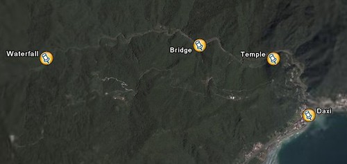
  • Daxi Fish Market: Some of us went down to the Daxi harbor afterwards. Walked around, snacked, and ended up buying a big fish right from a fisherman. Chris carried our big fish to a nearby restaurant where we had all 6kg of it converted into sashimi, fish soup, and steamed fish. Add some vegetables, noodles, rice, and a bit of beer, and the dinner was great.

Timing:
As I was keeping track of time pretty closely, I’ll mention some timing info. We drove to Daxi via the new long tunnel on Freeway 5. Early morning Sunday there was very little traffic (8:30am-9:30am). The trip from Mucha MRT Station to the temple along Daxi River took just under an hour. As for hiking, it took us approximately 3 hours to reach the main waterfall (at the end) and about 3 hours to return to the temple. Coming back was a bit faster, but we stopped less, until we were near the road. On average, we hiked for two hours out of three each way. The other hour was spread out among different rest and swimming breaks. We returned to the temple just as the sun was starting to touch the tops of the mountains. Good margin of daylight. Some of us took the Freeway 5 tunnel back to Taipei as well. At 8:30pm, it was far more congested. It took us 30 minutes from the start of the freeway entrance to the actual tunnel entrance, and another 30 minutes to travel through the tunnel. After that, smooth sailing. All in all, still only 1-1/2 hours back from Daxi to Xindian, so even with the tunnel congestion, it was as fast as any other route.

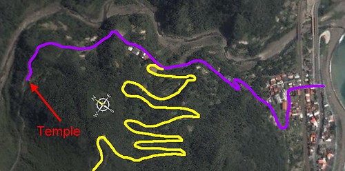
Lessons Learned:- It is possible to drive beyond the temple, as people were doing it when we arrived and while we walked down the road. They just opened the gate and drove through. Didn’t see a lock, but I didn’t look hard for it. However, don’t know if that temple gate is ever locked. Wouldn’t want to go through and then get our car locked behind the gate at the end of the day.

  • Crossing the bridge at the end of the temple road was a good idea. After crossing it, we walked on the dirt road and path along the river on the north side until it turned sharply to the north. Then, in the water. The map shows that road continuing past the bridge. Not really. It is an overgrown two-track that often disappears or turns to a footpath. Still, it was a time- and foot-saver.

  • At yesterday’s water levels (normal/low), the hike up from the temple to the waterfall is challenging, but not very difficult if done with plenty of daylight. Lots of places to step on dry rocks. Lots of shallow wading. Some deep wading. Surprisingly large number of deeper spots. Good water flow all along the way.

  • Water shoes were not made for hiking, especially for hours. They were made for fishermen to stand around on slippery rocks and move a little. While the soles of the local water shoes (fabric soles) are thicker and provide more traction than rubber soles, they are still too thin for comfort. I’m going to look for some good insoles for my water shoes. Preferably some with arch support.

  • Bigger trees. I need bigger trees. I’ll get there next time …

It was really nice to finally meet Trailhacker, Snafu, and Irishstu’s friend, Ken, and see everyone else after a long break. Trailhacker was our GPS man (BTW, Trailhacker: please post the GPS coordinates that you have). Snafu gets credit for discovering the location of the main falls. Ken gets credit for running from the leeches like a girl. :wink:

Some photos – unfortunately, didn’t get any of the fish market:

Crossing the bridge near the beginning of the hike:

“Marching to the beat of a different drummer …”

On the dirt road before jumping in the river:

First river crossing:

One of many breaks along the way:

Main pool at the biggest waterfall:

Trailhacker hard at work:

Main waterfall:

Cameraman’s favorite:

Irishstu: “What’s that?”
Kitty: “That???”
Trailhacker: “It’s plainly an igneous basalt boulder. And its precise GPS location is 336020 …”

See you next time!

Exaclty, that’s what they were. Was quiet interesting to watch them crawl up the rocks. And there were thousands of them.

Yes, there was a U-Lock around the gate. But we did observe how one person took the key for the lock out of the temple.

oh, i was wondering where you guys were headed when you said you were going out to eat. oh well, it doesn’t sound too vegi-friendly anways…

Ahh, but it was friendly, and that’s what really counts!

We determined that the fish we ate was a bonito.

The descriptions are dead on.
Here’s a few of the pics I took on the hike, the scenary was beautiful.
evilasad.com/gallery/daxi